Analysis of satellite imagery and thermal anomalies detected by NASA’s Fire Information Management System (FIRMS) confirm widespread destruction of residential areas in Murnei and Tawilah in West and Central Darfur, in what appears to be a campaign of ethnically targeted violence by the RSF.
Murnei, West Darfur
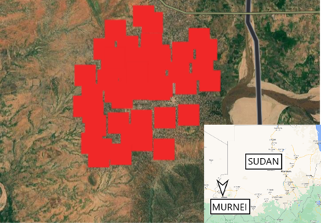
On 27 and 28 June 2023, NASA FIRMS detected multiple heat signatures covering the city of Murnei in West Darfur. (Figure 1).

Figure 1: NASA FIRMS data confirming heat signatures in Murnei on 27 and 28 June [12.95418417,22.87500638]
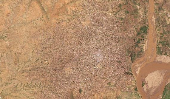
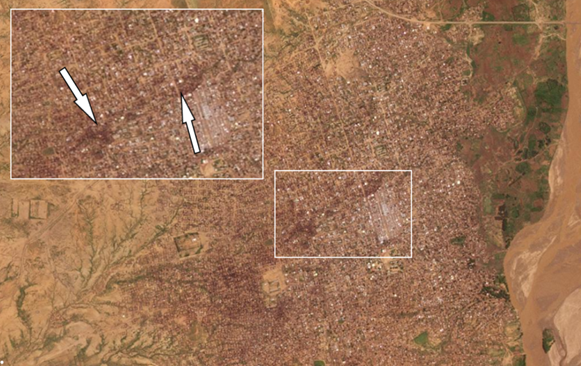
Analysis of available satellite imagery from the 26 and 28 June 2023 (Figures 2 and 3) shows fire damage to large areas in the centre of the city, as indicated by the black marks visible in the 28 June footage. The Humanitarian Research Lab at Yale University estimates that around 2km of the city was affected, equal to around 280 football fields. From the imagery and the FIRMS data, we can discern that the fires began on 27 June and were of sufficient intensity and duration for heat signatures to still be distinguishable on the 28 June.

Figure 2: PlanetLabs image of Murnei on 26/06 [12.95418417,22.87500638]

Figure 3: PlanetLabs image of Murnei on 28/06 showing fire damage [12.95418417,22.87500638]
Murnei is 80.5km south east of El Geneina, the capital of Darfur, and has been the focal point for attacks based on ethnicity in the region by militias and the RSF, according to the UN. In a statement to CIR, a Resistance Committee member from Darfur stated that this was a tactic commonly used by militias to render entire areas inhabitable.
Tawilah, Central Darfur
Further violence was observed in the village of Tawilah, Central Darfur. The village is located on the A5 main road between El Geneina and Al Fashir, making it easily accessible to armed forces moving around the area.
The attack on Tawilah by the RSF was first reported on 16 June 23 by UN OCHA, with CNN reporting that the RSF had seized Tawilah’s SAF garrison on 19 June 23. Residents started fleeing the village soon after clashes between SAF and RSF erupted, with the IOM estimating around 19,000 residents displaced and an unknown number killed or injured. Displaced citizens later testified that RSF attacked the city, killing and robbing civilians and burning houses.
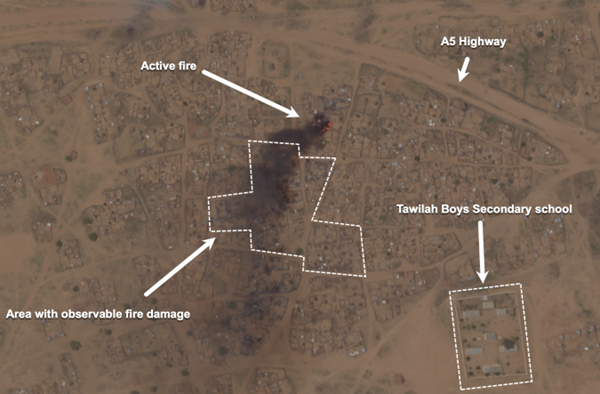
Fires in residential areas were first observed with FIRMS on the day of the reported attack (16 June). On 28 June 23, fires were detected at the market area and another fire in residential area was detected on 3 July 23 (Figure 4).

Figure 4: Satellite image captured by Planet of fire with a large smoke plume in a residential area in Tawilah, North Darfur on 3 July 23.
The marked area indicated where fire damage was observed from earlier fires, since 16 June 23. (Source: Planet Labs) [13.524740,24.863955]
لقراءة المقال بالعربية

