
By Mirte den Braber With contributions from Sofia Santos and Guy Agam Fusfus
Executive Summary
Since the start of the siege of Mariupol on 24 February, civilian infrastructure in the city has been systematically targeted by Russian military forces. Despite denials by the Kremlin that their military has targeted civilian infrastructure, our investigation reveals clear evidence of harm to such targets. This represents a breach of international law.
Our report focuses on the targeting of a total of 36 schools and universities throughout the four city districts of Mariupol: Zhovtnevyi, Kalmiuskyi, Prymorskyi and Livoberezhnyi.
The report describes each individual school that has suffered damage from battles in Mariupol since the beginning of the Russian invasion. Contrary to the Russian government’s denials, our work adds to the body of evidence showing how Russia has systematically targeted civilian infrastructure.
1. Introduction
Since the start of the invasion of Ukraine, civilian infrastructure has been systematically targeted by Russian military forces. This report aims to provide an overview of damaged and destroyed infrastructure with a focus on educational facilities in the city of Mariupol.
It will analyze 36 educational facilities that were either destroyed or damaged by bombings, shelling and fighting in Mariupol.
The map in figure 1 provides an overview of the locations of all destroyed and damaged educational facilities in the city of Mariupol.
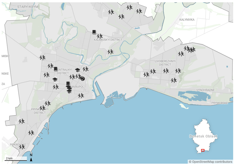
Figure 1: Overview of all destroyed and damaged educational facilities
This report is split up into 4 parts, each part discussing individually damaged or destroyed schools according to the particular district in which they are located.
The first part will be Zhovtnevyi district, the second Kalmiuskyi District, the third Prymorskyi District and the last part will be Livoberezhnyi district.
2. Zhovtnevyi District
This part of the report focuses on all damaged and destroyed educational facilities in the Zhovtnevyi district.
The section discusses three university facilities of which one is a volleyball complex, one a college, one medical institute, seven schools, one lyceum and one art school.
Figure 2 maps out the locations of affected educational facilities in this district.
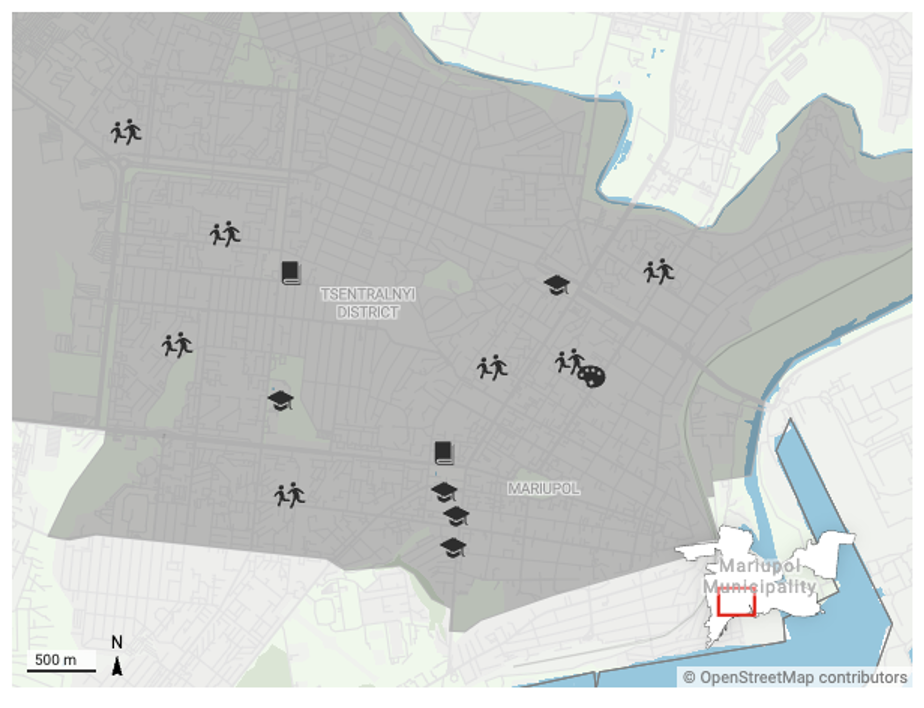
Figure 2: Overview of all destroyed and damaged educational facilities in Zhovtnevyi District
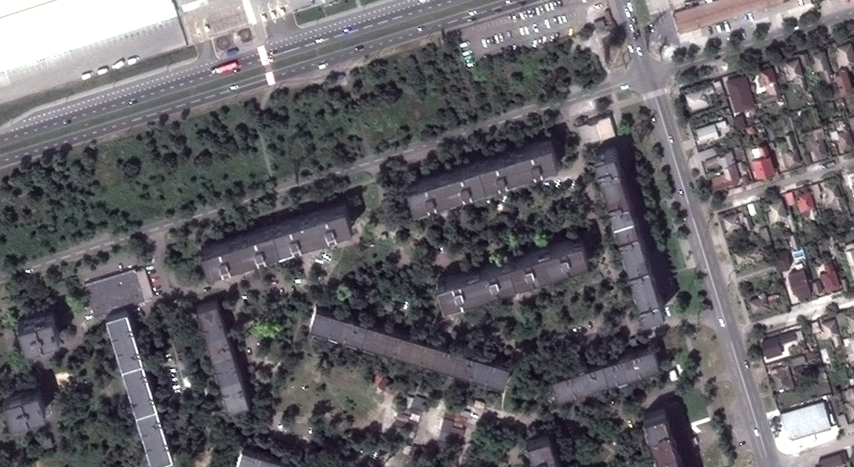
Destruction of Pryazovskyi State Technical University
Geolocated to: 47.095426477997925, 37.541080541723744
A video posted on 9 March shows the aftermath of a strike that hit Pryazovskyi State Technical University.
Figure 3 shows the complex before and after its destruction by Russian shelling. A video evidencing the destruction shows part of the building has completely collapsed whilst the rest has suffered severe damage.
Additional footage confirms the heavy damage that was caused to the building as a result of a strike.
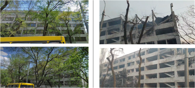
Figure 3: A comparison of the Pryazovskyi State Technical University before (left) and after (right) the strike hit
Images posted in a news article on 10 March show further damage to the University after the rocket attacks.
According to the article, the attacks happened on 9 March, not only destroying the university but also its surroundings and other infrastructure including a children’s hospital and a maternity hospital.
Figures 4a and 4b show the footage used in the article evidencing the destroyed university building.
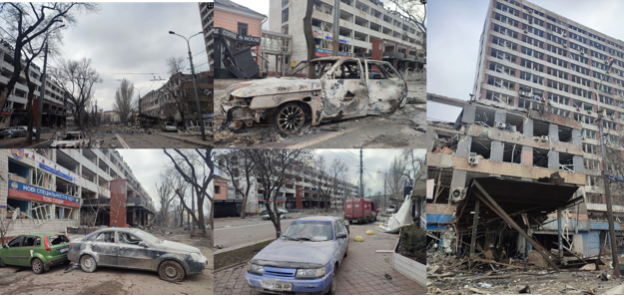
Figure 4a: Images of the destroyed Pryazovskyi State Technical University building and its surroundings
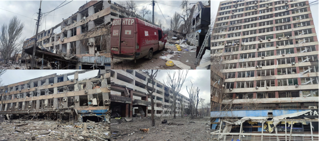
Figure 4b: Images of the destroyed Pryazovskyi State Technical University building and its surroundings
An image posted on 20 April shows the old building from the Pryazovskyi State Technical University having suffered damage.
Shelling marks are visible, as well as shattered windows and a part of the brick wall destroyed.
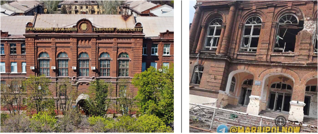
Figure 5: Images of the old building of Pryazovskyi State Technical University before (left) and after (right) damage
Destruction of the Faculty of Economics and Law of Mariupol State Humanitarian University
Geolocated to: 47.101487, 37.525378
An image posted on 6 April shows the faculty of Economics and Law of the Mariupol State Humanitarian University partially destroyed and heavily damaged.
The footage displays that part of the building, presumably the entrance hall, has collapsed.
Furthermore, the facade of the building is heavily damaged with visible shelling marks and shattered windows.
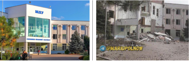
Figure 6: Faculty of Economics and Law of Mariupol State Humanitarian University before (left) and after (right) destruction
Damage to Volleyball Complex of Mariupol State Humanitarian University
Geolocated to: 47.091776, 37.542023
In addition to the Faculty of Economics and Law having suffered damage, the Volleyball Complex of Mariupol State Humanitarian University was also shelled.
An image posted on April 12 shows extensive damage to the building, with shelling marks and rubble covering the exterior.
In a video posted on April 13, the destruction is also visible.
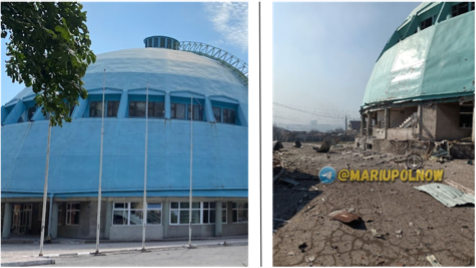
Figure 7: Volleyball complex of Mariupol State Humanitarian University before (left) and after (right) damage
Damage to Vidokremlenyy Strukturnyy PidrozdilCollege
Geolocated to: 47.109773, 37.526354
A post from 9 April shows Vidokremlenyy Strukturnyy Pidrozdil heavily damaged. One of the videos shows a fire in front of the college building.
The building itself suffered severe damage, as the windows are shattered or broken, the outside brick walls have in some parts been destroyed and there is visible damage to the entrance ceiling.
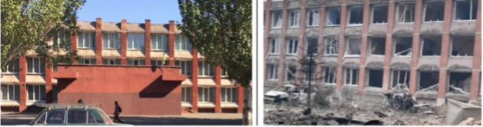
Figure 8: College before (left) and after (right) damage
Destroyed Medical Institute
Geolocated to: 47.109026, 37.551981
In a video from 1 April, a medical institute is seen under severe damage.
The footage shows that all the windows have been completely broken and large parts of the building are destroyed as seen by the large holes in the walls.
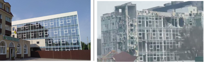
Figure 9: Medical Institute before (left) and after (right) destruction
Damage to School #9
Geolocated to: 47.095229, 37.526303
An image posted on 26 April shows damage to school #9 in Mariupol.
The windows are visibly damaged and taken from another post, the damage is visible to the exterior brick wall.
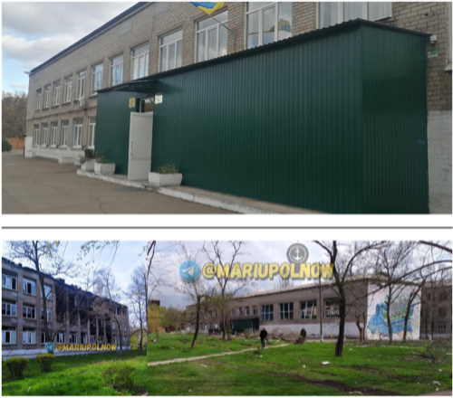
Figure 10: School #9 before (top) and after (bottom) damage
Damage to School #25
Geolocated to: 47.10504437, 37.5154882
In a video posted on 16 April, school #25 is seen following heavy damage from shelling.
Windows are shattered and broken and the inside of the building is covered in rubble and damaged school furniture.
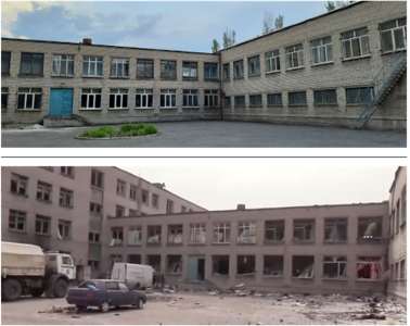
Figure 11: School #25 before (top) and after (bottom) damage
Destruction of School #36
Geolocated to: 47.1098462, 37.5617329
Pictures posted on 20 March and 29 April show heavy damage to school #36.
The images show that on one side of the building part of the exterior walls have broken down. For more see figure 12.
Figure 12: Before (left) and after (right) the damage to school #36 in Mariupol
Damage to school #52
Geolocated to: 47.11234929389294, 37.52010371567336
Footage emerging on 10 April shows significant damage to School #52.
The visible damage includes: damage to the roof covering the entrance of the school building, and shattered windows, while the inside of the building is covered with rubble.
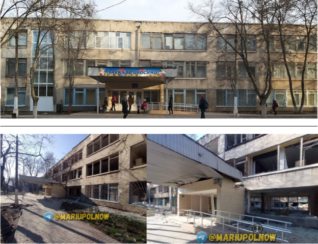
Figure 13: School #52 before (top) and after (bottom) damage
Damage to School #65
Geolocated to: 47.1035976244992, 37.5457996141281
A video posted on 23 April shows school #65 having suffered extensive damage.
Visible in the video are broken windows. In an image from 12 April, the damage is more visible. Some of the window frames are broken as well as some damage to the school walls.
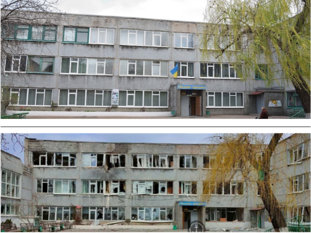
Figure 14: School #65 before (top) and after (bottom) damage
Destruction of School #66
Geolocated to: 47.103984369119935, 37.55331396679625
The result of shelling on school #66 can be seen in a video posted on 16 March.
The school is destroyed, with shattered windows and some parts have collapsed.
This is especially seen in a video posted on 7 April, showing how one side of the school has been severely hit and has completely fallen apart.
Another image from 10 April gives an overview of the school and the damaged surrounding residential buildings. In this image part of the school has collapsed.
Figure 15 portrays the before and after of the shelling on the school.
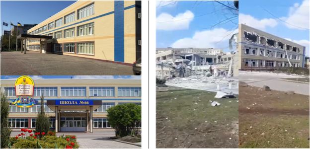
Figure 15: Before (left) and after (right) the shelling of school #66 in Mariupol
Damage to school #67
Geolocated to: 47.11906480520633, 37.51048467050041
An image from 11 April shows some damage to school #67. Some damage to the windows and part of the wall is visible.
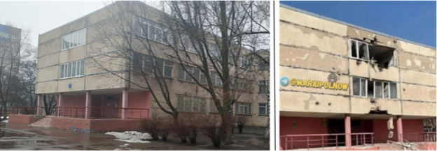
Figure 16: School #67 before (left) and after (right) damage
Damage to Mariupol City Lyceum
Geolocated to: 47.0979886933695, 37.5410917949269
The Mariupol City Lyceum has suffered some damage following extensive Russian shelling. This is apparent from images posted on 24 April.
Some of the windows have been shattered and a small part of the exterior brick wall seems to have collapsed.
Figure 17: Mariupol City Lyceum before (top) and after (bottom) damage
Damage to the Art school
Geolocated to: 47.102968, 37.555316
An art school located in a residential building has been severely damaged.
A video posted on 31 March shows the building in which the art school was located and surrounding residential buildings having been heavily damaged.
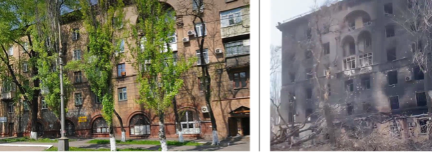
Figure 18: Before (left) and after (right) heavily damaged art school
3. Kalmiuskyi District
The second part of the report examines damaged and destroyed educational facilities in the Kalmiuskyi district.
This section examines five schools, one kindergarten and one technological lyceum, totalling seven educational facilities. Figure 19 maps out the locations of the educational facilities discussed in this part.
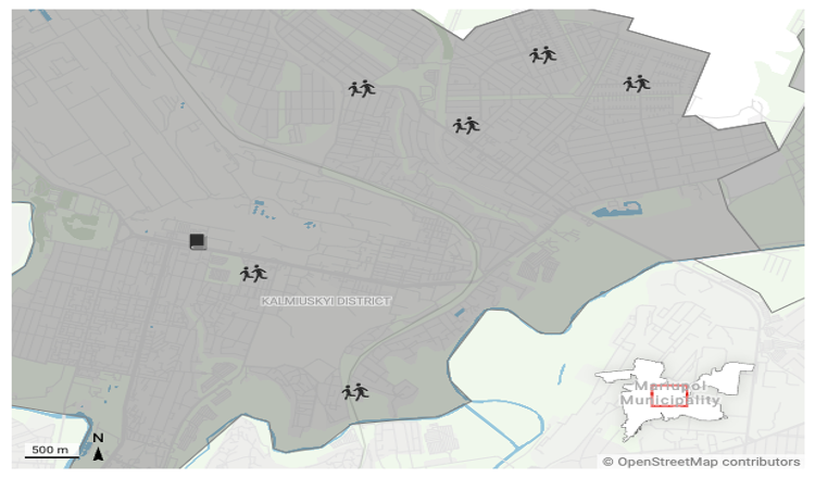
Figure 19: Overview of all destroyed and damaged educational facilities in Kalmiuskyi District
Damage to School #4
Geolocated to: 47.123781837525506, 37.59113883356332
A post from 10 April shows the damaged building of school #4. The main damage concerns the shattered windows.
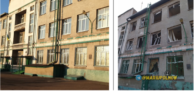
Figure 20: Images of school #4 before (left) and after (right) damage
Destruction of School #20
Geolocated to: 47.136495, 37.578732
A video posted on 31 March shows the partial destruction of school #20.
A wall seems to have collapsed and the building is covered in rubble. Surrounding residential buildings have also been heavily damaged.
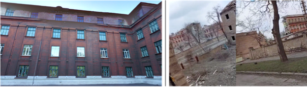
Figure 21: School #20 before (top) and after (bottom) destruction
Damage to school #24
Geolocated to: 47.152222, 37.604472
School #24 can be seen damaged in videos posted on 25 April.
On the exterior of the school, the main damage seems to be some shattered windows.
However, on the interior damaged furniture is visible, as well as floors covered in rubble, and a collapsed wall, and in one of the videos it can be seen that part of the ceiling has collapsed.
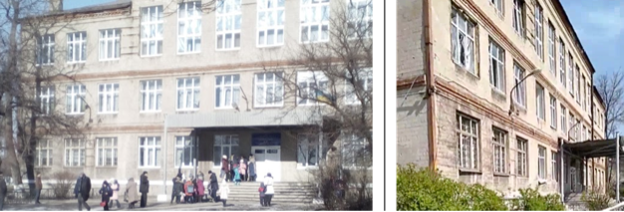
Figure 22: School #24 before (left) and after (right) damage
Destruction of School #30
Geolocated to: 47.1567127510746, 37.625198718090076
A video posted on 18 March shows school #30 and its surroundings heavily damaged following extensive Russian shelling.
In a different video, one side of the school building has been destroyed and collapsed. Additionally, the houses in the area surrounding the school have been struck by shelling.
Further images also show the damage to the interior of the school. Figure 23 shows a comparison of the school before and after it was destroyed.
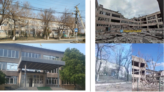
Figure 23: Before (left) and after (right) the destruction of school #30 in Mariupol
Damage to School #45
Geolocated to: 47.1561152912523, 37.5918425974082
In footage emerging on 26 April, school #45 is evidenced to have suffered heavy damage.
Large holes can be seen in the building where walls have been destroyed and collapsed, and part of the roof has been damaged as well as the windows.
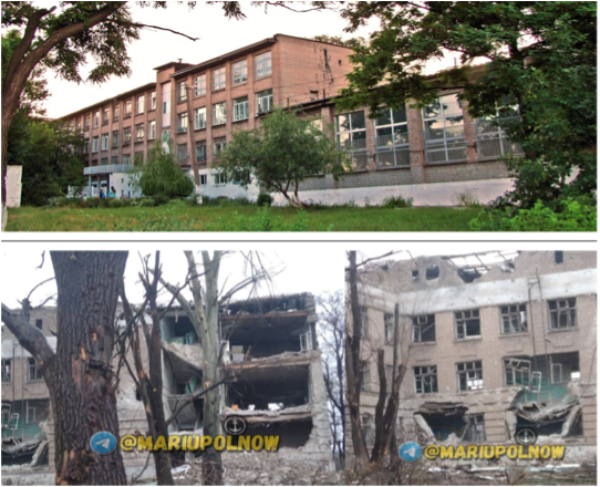
Figure 24: School #45 before (top) and after (bottom) damage
Damage to Kindergarten #167
Geolocated to: 47.159792204340114, 37.613751208534225
An image posted on 24 April on Telegram shows Kindergarten #167 with heavy damage, following shelling.
Images show that a part of the exterior wall has collapsed.
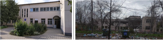
Figure 25: Kindergarten #167 before (left) and after (right) damage
Damage to Technological Lyceum
Geolocated to: 47.1398153818979, 37.5720466864177
Images of Mariupol Technological Lyceum, posted on 26 April, show the building with heavy damage.
The footage shows extensive damage to the windows and the outside wall is covered in burn marks.
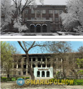
Figure 26: Technological Lyceum before (top) and after (bottom) damage
4. Prymorskyi District
The third part of the report examines all the educational facilities that suffered damage in the Prymorskyi district of Mariupol.
A total of six schools will be analyzed. The map in figure 27 shows the locations of these six schools.
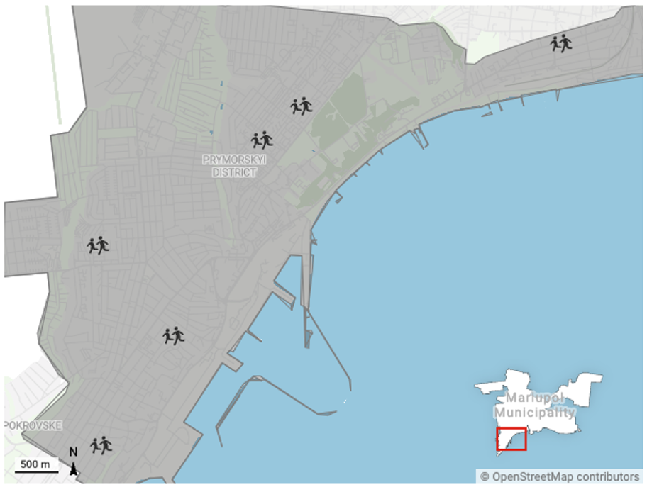
Figure 27: Overview of all destroyed and damaged educational facilities in Prymorskyi District
Destruction of School #15
Geolocated to: 47.06742476430629, 37.485702980559
In footage emerging on 27 March, it appears that school #15 is mildly damaged.
The walls have shelling marks and a crater can be seen in the yard. However, in videos from 22 April, the building can be seen as having suffered more severe damage.
It shows that the exterior of the building has been largely stripped away and the entrance to the school destroyed.
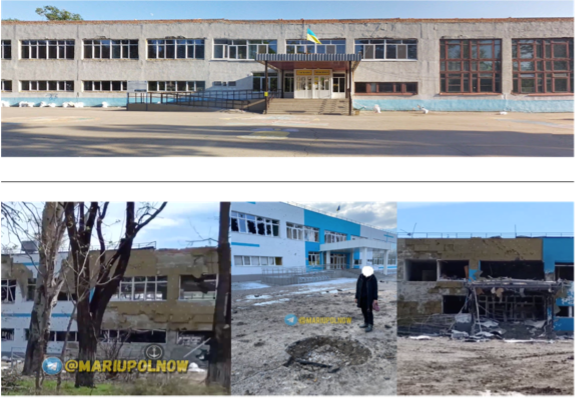
Figure 28: Before (top) and after (bottom) the damage to school #15 in Mariupol
Damage to school #26
Geolocated to: 47.078355, 37.510707
In a video posted on 26 April, both interior and exterior damage to school #26 in the Prymorskyi district is visible.
Inside the school, furniture in classrooms is damaged, as well as the ceilings.
The outside of the building is also heavily damaged with shattered windows and pieces of the building’s exterior either ripped off or containing shelling marks.
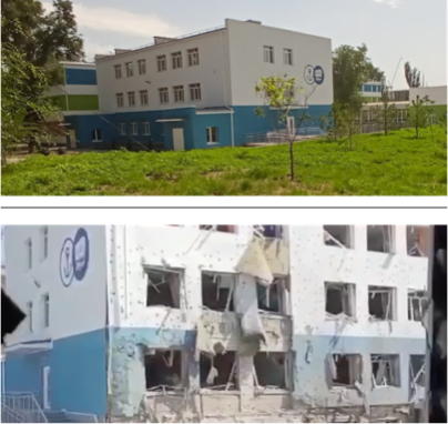
Figure 29: School #26 before (top) and after (bottom) suffering heavy damage
Destruction of School #32
Geolocated to: 47.0580616973594, 37.4972279893726
School #32 is partially destroyed and heavily damaged, as seen in footage from 20 April.
In the images, a large hole can be seen in the building as the walls have broken down and windows were shattered.
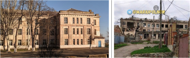
Figure 30: School #32 before (left) and after (right) damage
Damage to School #33
Geolocated to: 47.0466392399925, 37.4861040434988
A video posted on 22 April shows extensive damage to school #33. Predominantly visible are some shattered windows and rubble in front of the building.
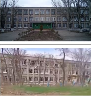
Figure 31: School #33 before (top) and after (bottom) damage
Damage to School #37
Geolocated to: 47.0884010429283, 37.5562249133187
In footage posted on 26 April, extensive footage is seen on school #37. Noticeably the school contains burn marks, suggesting the dire effect of continuous shelling.
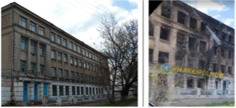
Figure 32: School #37 before (left) and after (right) damage
Damage to School #54
Geolocated to: 47.0819710052892, 37.5165957035024
Images from 26 April and a video from 21 April show the heavy damage and partial destruction of school #54.
The building’s exterior has appeared to suffer extensive damage. Additionally, one part of the school has been destroyed, with the walls collapsed into rubble.
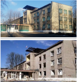
Figure 33: School #54 before (top) and after (bottom) damage
5. Livoberezhnyi District
The last part of this report focuses on schools located in the Livoberezhnyi district.
A total of nine schools will be discussed including one makeshift graveyard at a kindergarten.
Figure 34 maps out the locations of all the schools discussed in this part.
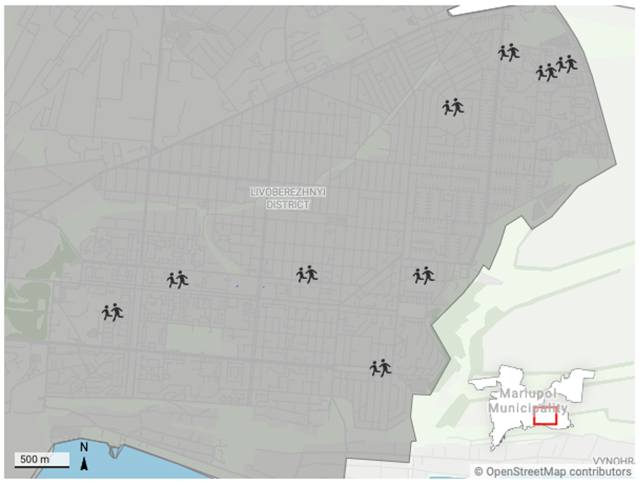
Figure 34: Overview of all destroyed and damaged educational facilities in Livoberezhnyi district.
Damage to school #2
Geolocated to: 47.10095309714291, 37.66543131331871
In a video posted on social media platforms on 9 April, school #2 is visibly damaged.
The building appears to have burn marks on the walls and the windows are shattered. Houses surrounding the school have also sustained heavy damage.
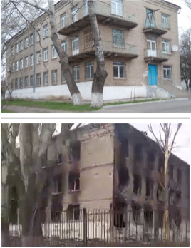
Figure 35: School #2 before (top) and after (bottom) damage
Damage to school #14
Geolocated to: 47.108400, 37.657317
In a video emerging on 12 April school #14 is heavily damaged.
The damage was inflicted mainly to the gate in front of the school with parts of the fence having been destroyed.
The area surrounding school #14 is more heavily damaged with the roofs of residential buildings having completely collapsed. In a video from 31 March, further damage to surrounding residential buildings is clearly visible.
Figure 36 shows before and after footage of the damage to school #14.
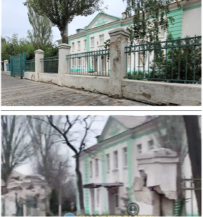
Figure 36: School #14 before (top) and after (bottom) destruction.
Destruction of School #40
Geolocated to: 47.108027, 37.641612
Drone footage showing school #40, posted on 30 March, shows that the roof of the school has collapsed.
More images from the 2 May evidence mild damage to the front of the school.
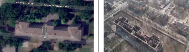
Figure 37: Satellite image of the school (left) and the drone footage of the collapsed roof (right)
Damage to School #41
Geolocated to: 47.1083573409473, 37.6714435029665
A video posted on 24 April and an image posted on 28 April show a damaged school #41. Mainly visible are the broken windows.
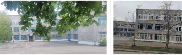
Figure 38: School #41 before (left) and after (right) damage
Destruction of school #55
Geolocated to: 47.105339, 37.633709
Images posted on 5 April and 27 April show school #55 partially destroyed.
One part of the building has completely collapsed into rubble. The rest of the building suffered damage with shattered or blown-out windows.
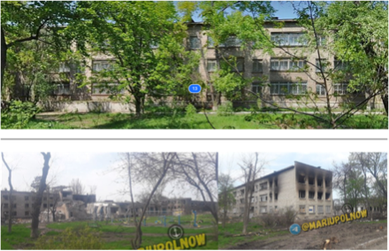
Figure 39: School #55 before (top) and after (bottom) destruction
Destruction of School #57
Geolocated to: 47.122231251326, 37.6750108592367
Footage emerging on 16 April shows heavy damage to school #57 in the Livoberezhnyi district of Mariupol.
A video posted later, on 26 April, confirms the damage.
The windows of the school have been shattered or broken, a large part of the roof has been damaged and some parts have collapsed and the stairs to the entrance of the school have been destroyed.
Figure 40 shows school #57 before and after its destruction.
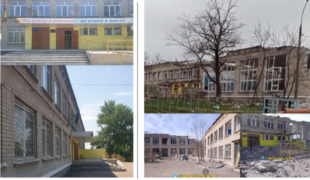
Figure 40: School #57 before (left) and after (right) destruction
Destruction of school #68
Geolocated to: 47.126702, 37.681781
School #68 in the Livoberezhnyi district has also suffered severe damage, as seen in a video posted on 28 April.
The video shows that the windows were blown out or shattered, a part of the roof collapsed and the exterior of the building was damaged.
In another post on 26 April, a video from the interior of the school shows the building covered in rubble, with holes in the walls and ceiling.
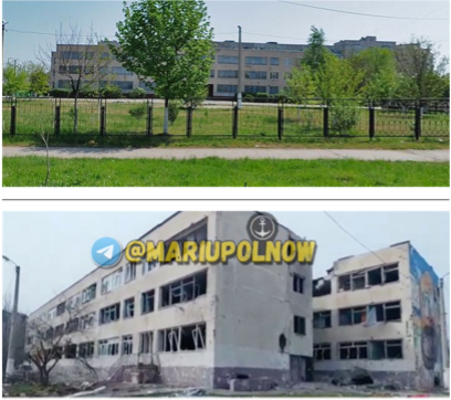
Figure 41: School #68 before (top) and after (bottom) destruction
Damage to School #69
Geolocated to: 47.1257168493555, 37.6888148999732
An image posted on 20 April shows school #69 with some damage following Russian shelling.
The exterior of the building is seen to have been significantly damaged.
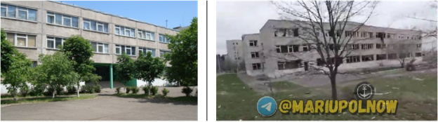
Figure 42: School #69 before (left) and after (right) damage
Makeshift graveyard at Kindergarten
Geolocated to: 47.125093, 37.686409
Images posted on 8 April and 10 April show the yard of a kindergarten in Mariupol turned into a makeshift graveyard.
The images show multiple graves scattered around the field, as well as a heavily damaged kindergarten in the background.
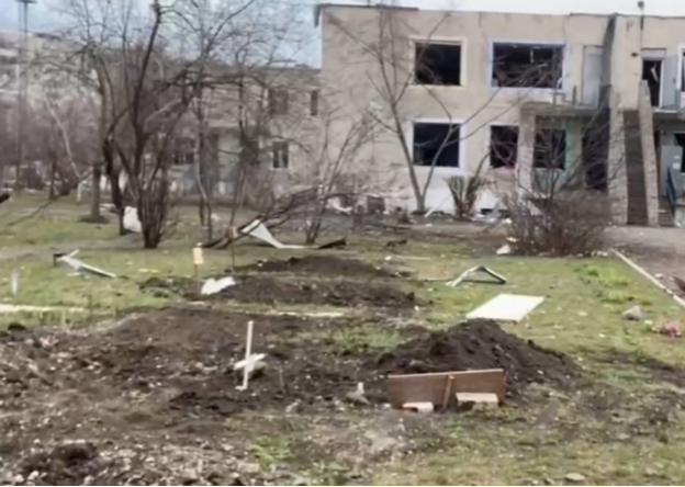
Figure 43: Image from the graveyard in the yard of a Kindergarten.