Myanmar Witness Fellowship
Houses razed in Palaw township, Tanintharyi region
Key Event Details
Location of Incident: Three villages in Palaw Township (ပုလောမြို့နယ်), Tanintharyi Region (တနင်္သာရီ တိုင်းဒေသကြီး).
To (တို) village [12.865942, 98.660944]
Tan Shin (တန်းရှင်း) village [12.873319, 98.668229]
Thin Gan Taw (သင်္ကန်းတော) village [12.877906, 98.671760]
Date/Time of incident:
30 December 2022
Alleged Perpetrator(s) and/or Involvement:
Myanmar Military
Conclusions by Myanmar Witness
Myanmar Witness documented 32 fire incidents in the Tanintharyi region during 2022.
On 30 December 2022, the villages of To village, Tan Shin village and Thin Gan Taw village in Palaw township experienced fires and over 60 houses were reportedly set alight by the Myanmar military.
Myanmar Witness verified the fires by geolocating and chronolocating user-generated content (UGC) showing the damage.
Myanmar Witness has verified that at least 48 houses were set on fire in the villages of To, Tan Shin and Thin Gan Taw.
Information gathered by Myanmar Witness suggests that Myanmar military are likely to be responsible for the fires.
Summary
Myanmar Witness’ ongoing fire monitoring recorded at least 32 cases of fires in Tanintharyi region (တနင်္သာရီ တိုင်းဒေသကြီး) during 2022. This report focuses on fires that happened on 30 December 2022, during which more than 60 houses were set on fire in three villages of Palaw township (ပုလောမြို့နယ်) in Tanintharyi region. Myanmar Witness verified that the fires occurred in To (တို), Tan Shin (တန်းရှင်း), and Thin Gan Taw (သင်္ကန်းတော) villages. Myanmar Witness concluded that the most likely perpetrator is the Myanmar military.
Background and Context
The military seized power and detained the officially elected government on 1 February 2021. Since then, the Myanmar military has repeatedly committed human rights violations such as arbitrary arrests and torture, setting entire villages alight, and mass killings across the country. In this report, Myanmar Witness investigates the three incidents that reportedly damaged or destroyed more than 60 houses in three villages during the last week of December 2022.
Prior to this event, Myanmar Witness’ monitoring reveals that at least 29 other fire incidents occurred in Tanintharyi during 2022. As previous reporting indicates, civilian homes are overwhelmingly impacted during these events. Homes were destroyed during at least three separate fire incidents in the first three months of 2022, 20 incidents in April, May, June and July, two incidents in September and October, and four incidents in November.
According to Dawei Watch, approximately 48, 7, and 14 houses were destroyed by the fire in To, Tan Shin, and Thin Gan Taw villages respectively in the last week of December. Through an in-depth investigation, Myanmar Witness has confirmed that at least 47 houses were damaged or destroyed by the fires.
Methodology & limitations
To read the methodology and limitations, download the PDF.
Fires in Tanintharyi township during 2022
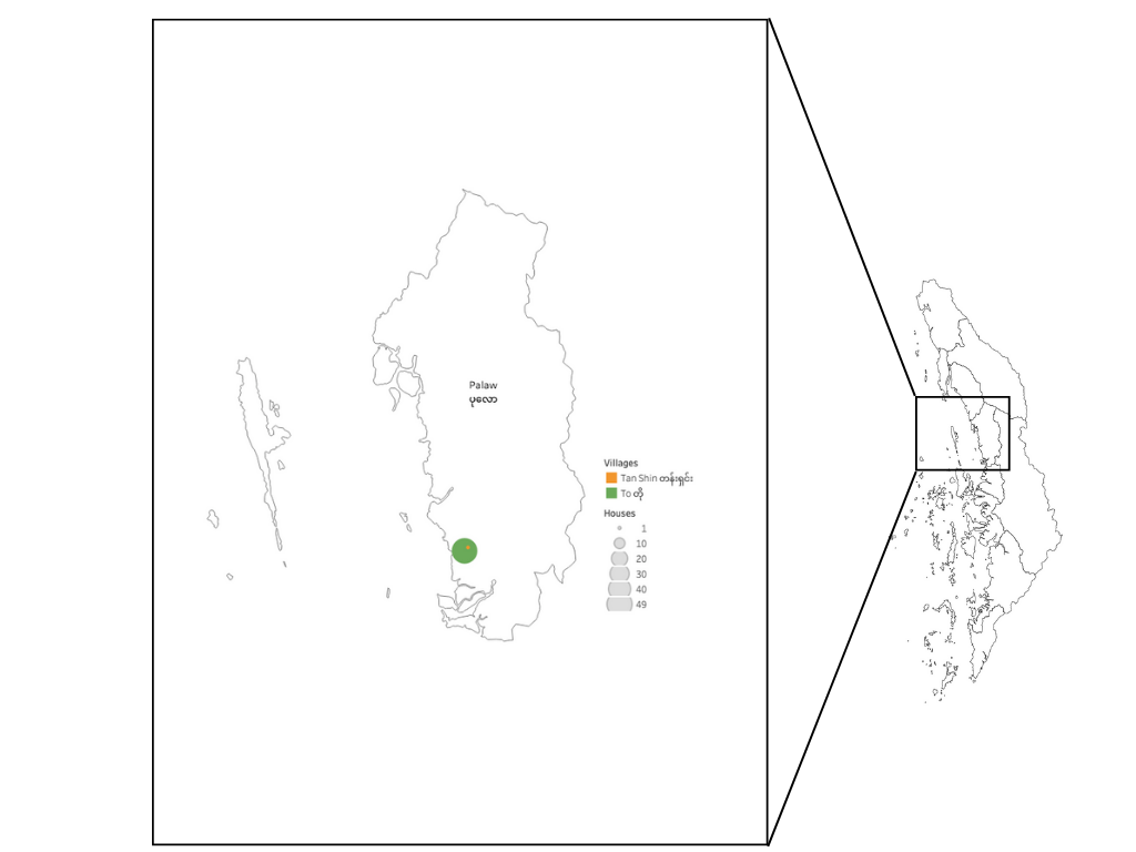
Figure 1: (Top) Myanmar Witness collected cases of fires in Tanintharyi region in 2022. (Bottom) Map showing the confirmed number of houses damaged by fires in Palaw township.
Timeline of Fires in 2022

Figure 2: Timeline of fires in Tanintharyi region in 2022 as documented by Myanmar Witness. Tsp – township.
Colour Code: Red – Fire cases with confirmed location and date. Orange – Fire cases with confirmed location. Yellow – Fire cases with confirmed date. Black – Unconfirmed fire cases.
Burnt homes in Palaw Township
Verifying the fires using geolocation
Myanmar Witness identified 46 houses in To village, and one house in Tan Shin village, that were damaged or destroyed by the fires.
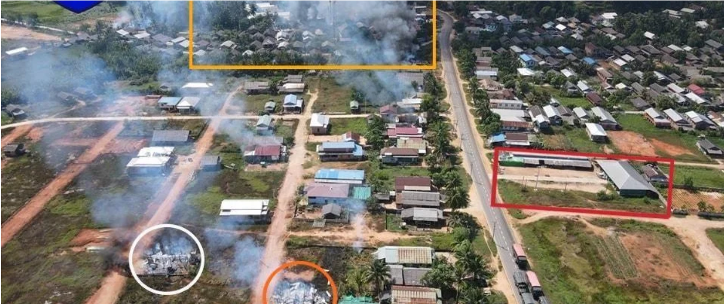
Drone footage captured the period when To village was engulfed in flames and smoke (Figure 3; top). Myanmar Witness fellows were able to geolocate the footage to the village using satellite imagery (figure 3; bottom).
During this analysis, Myanmar Witness scrutinised satellite imagery of the area over time. The house circled in white (figure 3) was not built in November 2021 (as it was not visible in the imagery from that period). This new house, along with the house circled in orange, which were both used during the geolocation, were completely destroyed by the fire.
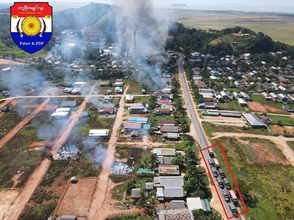

Figure 3: (Top) The smoke from To village can be seen in the drone footage. (Bottom) Satellite image showing the location where the smoke can be seen in To village [12.866234, 98.660912].
Myanmar Witness was also able to verify the extent of the damage on the ground using a video recording taken by two men driving a motorcycle through the destroyed village (source redacted due to privacy concerns). The footage was compared with satellite images to identify which houses were destroyed (figure 4). The route taken by the video recorders is shown with the red line, with the starting point of the video on the far right. The houses shown in yellow were damaged or destroyed by the fire, and Myanmar Witness was able to identify 40 damaged or destroyed houses. It is possible that more houses were destroyed, however these were not captured by the video footage.
Between November 2021 (when the latest imagery of To village on Google Earth was taken) and December 2022, new houses had been constructed in the village. For example, this investigation revealed two destroyed homes which were not visible in earlier satellite imagery. The location of these two houses is outlined in orange (figure 4). Additionally, figures 5 and 6 show the geolocations of five damaged houses to To village.
Figure 4: Geolocation of fire-damaged houses in To village according to the video footage [12.866163, 98.66078]. Each yellow pin represents a damaged house. The red line is the path taken by the video recorders. The orange frame shows the location of two houses that were seen damaged in the video but were not present in the satellite image (source redacted due to privacy concerns).
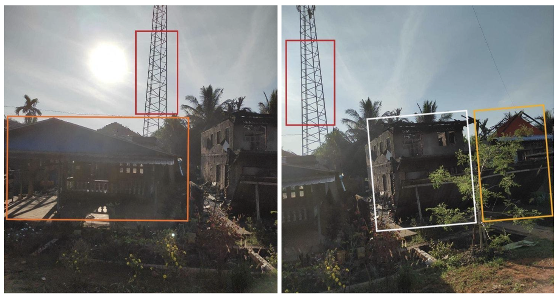

Figure 5: Geolocation of damaged houses in To village [12.867374, 98.661256] (Source: Burma Human Rights Network).
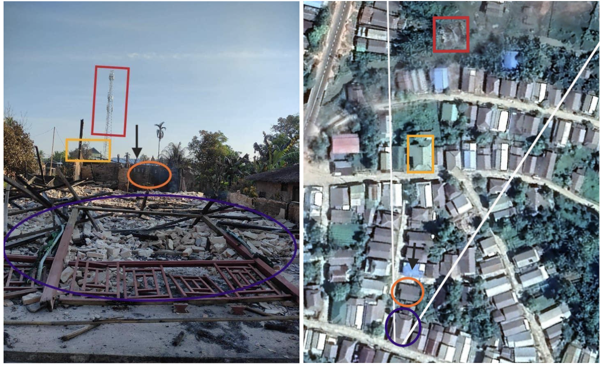
Figure 6: Geolocation of damaged houses in To village [12.865856, 98.660519] (Source – The Tanintharyi Times).
By comparing the drone footage and the satellite imagery, Myanmar Witness was able to confirm that the fires also occurred in Tan Sin, and Thin Gan Taw villages on the same day as smoke can be seen in the background of the footage (figure 7).
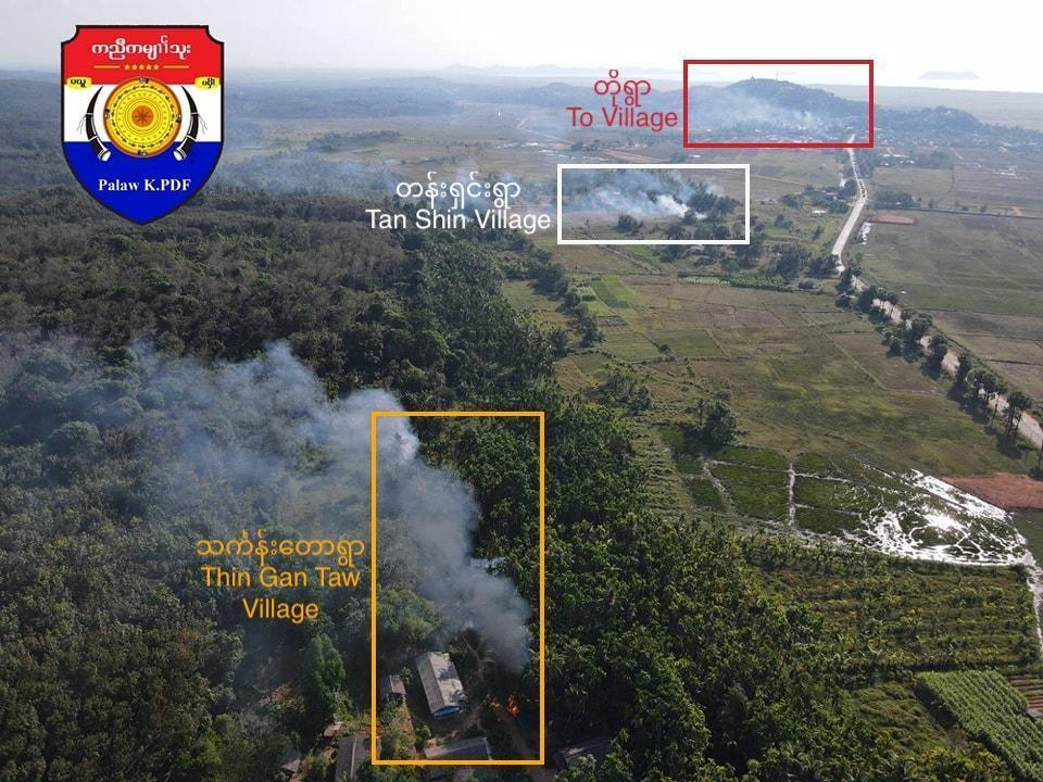

Figure 7: To [12.866258, 98.661175], Tan Shin [12.872581, 98.667883] and Thin Gan Taw [12.877884, 98.671793] villages can be seen in a photo (top) and a satellite image (bottom) (Source redacted due to privacy concerns).
Other images were also identified showing fire damage to homes in the area which the Myanmar Witness fellows were able to geolocate, strengthened the confirmation of the fire in Tan Shin village (figure 8).
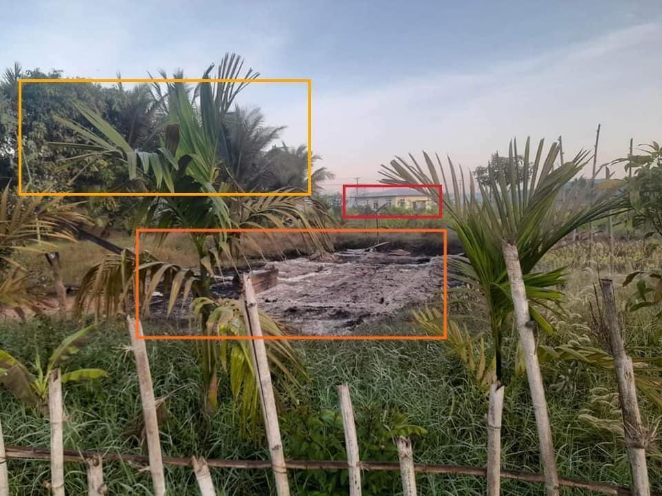
Figure 8: (Top) A view house destroyed by fire taken from a road in Tan Shin village (source: The Tanintharyi Times) and (bottom) the satellite view of the house [12.866234, 98.660912].
Additional drone footage released by the same source allowed the verification of the fire in Thin Gan Taw village (figure 9).
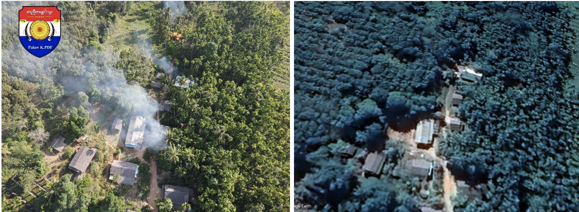
Figure 9: (Left) Fire in Thin Gan Taw village (Source redacted due to privacy concerns) and (right) the satellite view of the location [12.877862, 98.671740].
Chronolocation
Dawei Watch reported that the fires occurred in To, Tan Shin, and Thin Gan Taw villages on 30 December 2022. NASA’s Fire Information for Resource Management System (FIRMS) shows high temperature areas in To village on that day, corroborating that a fire had occurred on this day (figure 10).
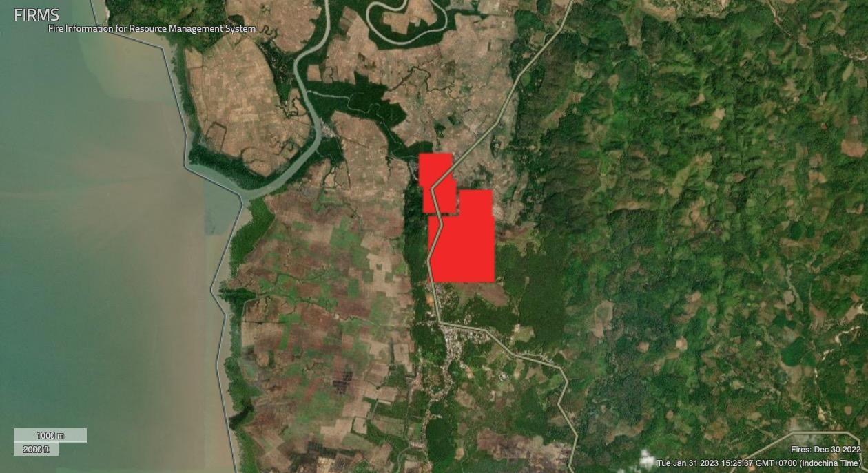

Figure 10: (top) NASA’s FIRMS image captured on 30 Dec 2022 shows high temperatures in To village and (bottom) the location of To village as shown by google maps [12.866391, 98.660766].
Sentinel Hub’s imagery provides additional evidence of the fire in To village. The smoke plumes from To village are clearly visible in the image captured on December 30 (figure 11).

Figure 11: The smoke plume is seen in a satellite image of To village captured by Sentinel Hub on December 30 [12.8658541, 98.660532].
The fires in Tan Shin village and Thin Gan Taw village were not registered by FIRMS or visible in Sentinel Hub satellite imagery; however, footages confirm that fires occurred in those two villages at the same time as the fire in To village (figure 12) (source redacted due to privacy concerns).
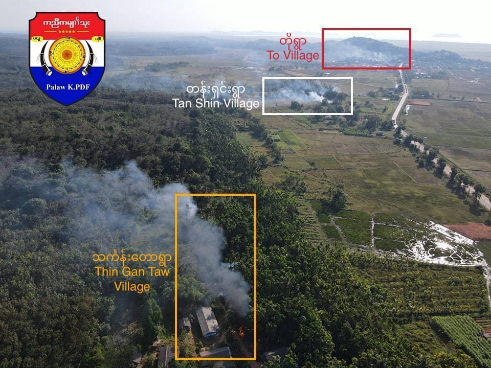
Figure 12: Simultaneous fires in To village [12.866258, 98.661175], Tan Shi village [12.872581, 98.667883], and Thin Gan Taw village [12.877884, 98.671793] (Source redacted due to privacy concerns).
Perpetrators
Myanmar Witness has previously and extensively reported on the use of fire by the military against villages with known anti-State Administration Council (SAC) links. In this case, when the drone captured footage of the three villages engulfed in smoke, a military convoy (outlined by the red box in figure 13) was visible near to the fires.
Myanmar Witness can confirm that the vehicles in the convoy are commonly used by the Myanmar military and has identified this type of vehicles within other military activity (figure 14). For example, the three vehicles shown in red in figure 14, left, are the same as those shown in figure 14, top right. The seven vehicles shown in white in figure 14, left, are identical to those seen in figure 14, bottom right.
Although there is no footage showing military personnel setting the fires alight, Myanmar Witness concluded that the presence of Myanmar military convoy in the vicinity of the fires increases the likelihood that they were the perpetrators.
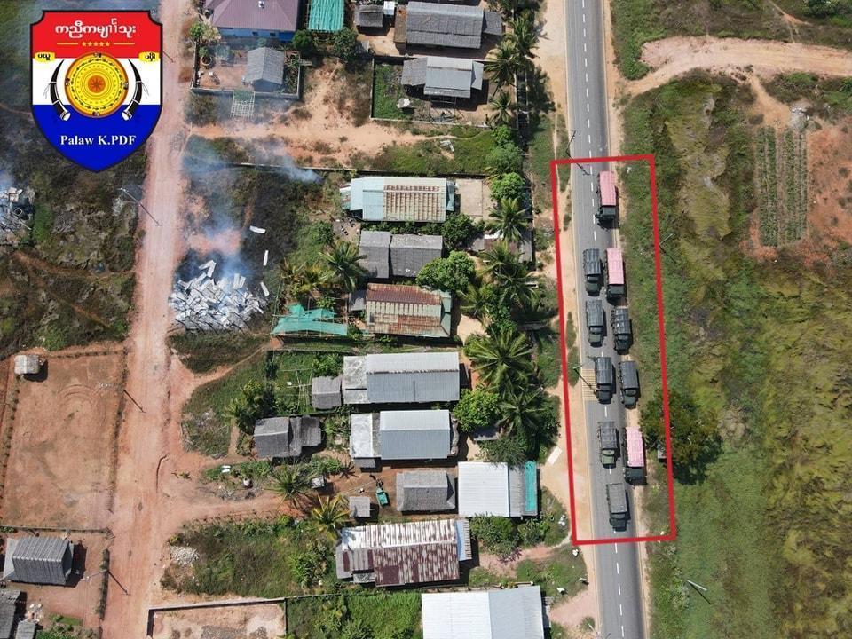
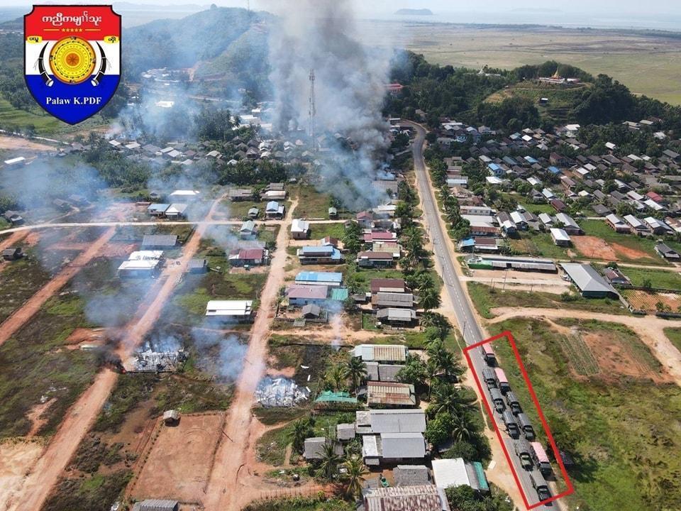
Figure 13: Convoy spotted at the time of the fire [12.868800, 98.662349]. See Figure 2 for the detailed geolocation.

Figure 14: Comparing the vehicles in the nearby convoy at the time of the fire. (Left) Comparison of the nearby convoy at the time of the fire (enlarged picture, source redacted for privacy concerns) with the (top right) type-1 vehicle and (bottom right) vehicle type-2, both used by the military.
Conclusion
In this investigation, the Myanmar Witness fellows investigated fires which led to the destruction of civilian homes in Palaw township, Tanintharyi region, on 30 December 2022. The location and time of the fires was verified using geolocation techniques (a location-based verification method) and chronolocation (a location-based time calculation method).
According to reports, about 69 houses were burnt down. Myanmar Witness concluded that at least 47 houses were damaged or destroyed by the fires. Given the presence of a military convoy in the vicinity of the fires, Myanmar Witness deems that it was likely that the Myanmar military was responsible for the fires. This is in line with other documented military activity.
Abbreviation List
Fire Information for Resource Management System – FIRMS
User Generated Content – UGC
State Administration Council – SAC

