Summary
Tensions continue to rise since Russian forces occupied the Zaporizhzhia Nuclear Power Plant (NPP). Both Ukraine and the international community have warned about the risk of endangering this critical energy plant.
Despite the warnings, Russia continues to endanger thousands through its actions. The Centre for Information Resilience’s Eyes on Russia (EoR) investigators have collected open source evidence showing Russian forces firing near the NPP. We also have clear evidence of Russian forces storing heavy military equipment around the NPP, creating a volatile situation.
Our team have also analysed footage showing the shelling of Energodar, the town near where the NPP is located. Despite Kremlin and pro-Russian denials, our analysis indicates it is highly likely that since August, Russian forces have shelled the town of Energodar from Russian controlled areas. .
Background
The Zaporizhzhia NPP in Energodar, located on the southern shore of the Kakhovka Reservoir on the Dnieper river in southeastern Ukraine, is the largest NPP in Europe and one of the largest in the world.
On March 3, Russian forces took control of the power plant. Rafael Grossi, head of the International Atomic Energy Agency [IAEA], expressed grave concerns about the physical integrity of the plant.
Russian forces at Zaporizhzhia NPP
For months, claim and counter-claim have been made around the presence of Russian military equipment at the NPP. We can reveal that visual evidence has been verified by EoR investigators, showing Russian forces present around the NPP.
We also have visual evidence of Russian forces using Multiple Launch Rocket Systems (MLRS) close to the NPP.
The stationing of heavy military equipment in and near the Zaporizhzhia NPP by Russian forces is most likely a deliberate choice, as targeting this equipment would significantly increase the risk of an incident around one of the reactors. This positioning therefore reduces the risk of Russian military equipment coming under attack.
On August 2, the Insider filmed drone footage of a convoy of military trucks entering the NPP – this included anti-aircraft guns, armoured personnel carriers and other military equipment near to reactor number two.

Figure 1: Left and right – Screen captures of Insider footage showing Russian military equipment being moved into the Nuclear Power Plant [47.509258, 34.583085].
Satellite imagery from August 29, shared by Maxar, indicated Russian military equipment stationed underneath the cooling pipes at reactor five.
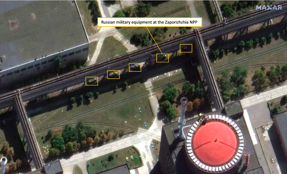
Figure 2: Satellite imagery provided by Maxar, showing Russian military equipment stationed at reactor five [47.513538, 34.589095].
Furthermore, Russia has set up fighting positions at the entrance to the power plant facility, as seen by the improvised walls and armed military personnel in front of the NPP.

Figure 3: Geolocation of Russian fighting position in front of the power plant [47.506728, 34.586201].
During the visit by the International Atomic Energy Agency [IAEA] mission to the Zaporizhzhia NPP on September 1, ‘Izvestia’, a daily broadsheet newspaper in Russia, shared footage showing IAEA members inspecting the inside of the NPP, while passing by Russian military trucks with the well known ‘Z’ markings.
On the night of September 2-3, footage was taken which allegedly shows Russian forces using a MLRS in the vicinity of the Zaporizhzhia NPP, firing towards an unknown location. EoR investigators verified the footage and confirmed that it was filmed from the Dnipropetrovsk Oblast, facing towards the Zaporizhzhia NPP.
The NPP and the nearby Zaporizhzhia thermal power station are visible in the footage. This footage indicates that Russia is using heavy military equipment near the Zaporizhzhia NPP.
The use of an MLRS by Russian forces within the vicinity of the NPP increases the risk of damage to the NPP site due to potential mis-fire of the MLRS.
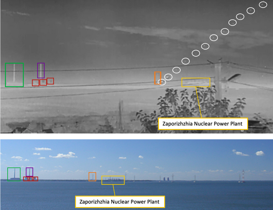
Figure 4: Verification of footage showing Russian forces using a MLRS system near the Zaporizhzhia NPP. With the Zaporizhzhia NPP visible [yellow], as well as the nearby Zaporizhzhia thermal power station [green, purple, red] and the rockets launched from the MLRS [white].
On September 4, Russian Telegram channel ‘Рыбарь’ [Rybar] tried to dismiss the footage showing Russia using an MLRS near the NPP by claiming the missiles were launched from the “other side of the Kakhovka reservoir”, away from the NPP.
However the geolocation of the footage by EoR investigators puts the launch area between the NPP and the Zaporizhzhia Thermal power plant, rather than in the area proclaimed by Rybar on the other side of the Kakhovka reservoir.
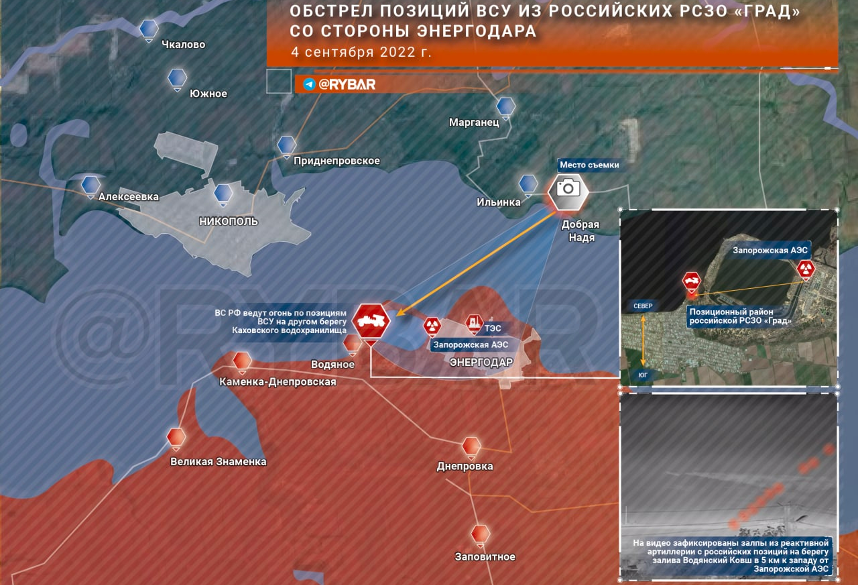
Figure 5: Russian Rybar claimed the missiles were launched from the other side of the Kakhovka reservoir, east of the NPP.
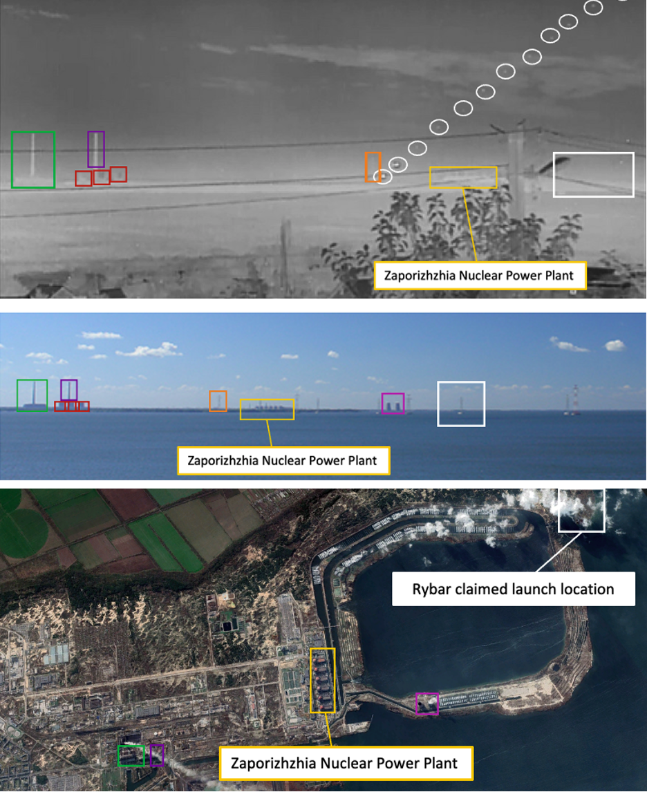
Figure 6: Verification of footage showing Russian forces using a MLRS system near the Zaporizhzhia NPP. The Zaporizhzhia NPP is visible [yellow], as well as the nearby Zaporizhzhia thermal power station [green, purple, red] and the Rybar claimed rocket launch location [white].
As can be seen in the figure above, the location from which Rybar claims the MLRS was launched does not match up with the trajectory of the rockets seen within the footage.
Direction of shelling
Open source evidence suggests Russian forces are shelling Energodar, a town under Russian control, approximately 4.5 kilometres from the Zaporizhzhia NPP.
On September 1, further shelling hit the town of Energodar. Footage showing shelling in front of a building in the city centre was geolocated to near the monument of Taras Shevchenko [47.499652, 34.657693].
EoR investigators analysed the footage and found evidence of a crater in the road, after the rocket struck the area. Careful inspection of this footage revealed a larger quantity of dirt on the left side of the crater. This indicated that the shell came from the right side of the camera.
The EoR investigators were able to trace the potential trajectory of the rocket and identify that it was launched from the southern side of the Dnipro river, Zaporizhia Oblast, which is fully under Russian control. Thus, EoR investigators were able to conclude that the shell launched at Energodar [a Russian controlled town] on September 2, originated from a Russian controlled area.
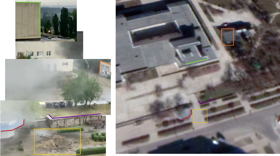
Figure 7: Geolocation of footage showing shelling in the centre of Energodar [47.499652, 34.657693]. Indicated in yellow is the area of shelling.
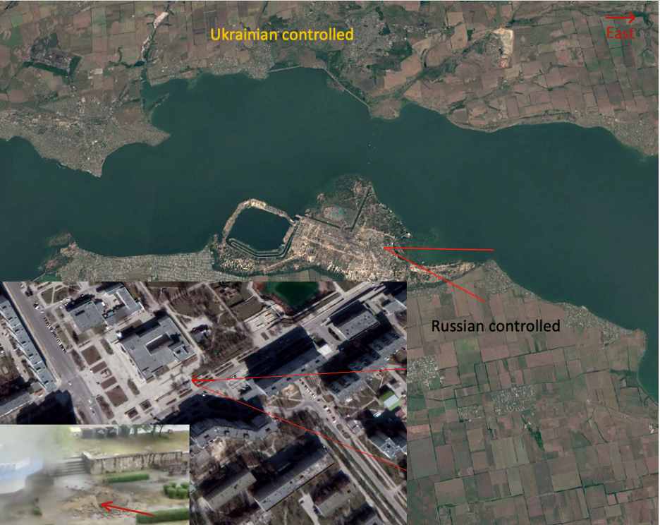
Figure 8: Approximate direction of travel from the shell as seen in footage on September 2, calculated using the direction of impact of the shell [bottom left]. Indicating the shell originated from a Russian controlled area.
Conclusion
Visual evidence has revealed Russian military activity around the NPP, including images which show Russian forces hiding military equipment around the reactors, and the use of MLRS systems near the NPP.
Although Russia, and pro-Russian media channels are actively trying to dismiss evidence of Russia using heavy military equipment near the Zaporizhzhia NPP, open source evidence suggests that Russian forces are themselves shelling Energodar, a town under Russian control.
The use of heavy military equipment near the Zaporizhzhia NPP by Russian forces, as well as the shelling of Energodar, only increases the risk of another nuclear disaster on Ukrainian territory.

