Key Event Details
Location of Incident: Sar Htone (ဆားထုံး) & Htan Zin (ထန်းဇင်) village tracts in Salingyi Township, Sagaing State
Date/Time of Incident:
Multiple events between 30 November 2022 and 1 December 2022
Alleged Perpetrator(s) and/or Involvement:
State Administration Council (SAC) troops
People’s Defence Forces (PDF)
Conclusions:
Multiple fires have occurred in four villages across the Sar Htone and Htan Zin village tracts.
Using sentinel imagery, Myanmar Witness identified around 210 burnt houses.
User-generated content (UGC) showing the fires was analysed and verified by Myanmar Witness.
Two elderly civilians allegedly died during the events; however, the cause of death remains unknown. One of the deceased civilians was visible within the analysed UGC.
Summary
On the evening of 30 November 2022, the SAC armed forces reportedly entered the town of Htan Zin (ထန်းဇင်), where they allegedly looted homes and set fire to property. The following morning, the forces moved on to the towns of Let Pan Kyun Lay (လက်ပံကျွန်းလေး), Let Pan Kyun Gyi (လက်ပံကျွန်းကြီး), and Taw Kyaung (တောကျောင်း). UGC and satellite footage shows extensive fire damage to these towns. During these attacks, two elderly people were allegedly killed. Footage of the corpses were identified by Myanmar Witness, and although they cannot be geolocated to the scene of the events, techniques such as reverse-image search show that the images have not been indexed by search engines in previous contexts.
Myanmar Witness has been able to verify:
Multiple fires have occurred in four villages across the Sar Htone and Htan Zin village tracts, Sagaing state.
Using sentinel imagery, Myanmar Witness identified around 210 burnt houses.
UGC showing the fire damage to the villages has been verified through geolocation. This corroborates claims made on social media as well as that shown in FIRMS data and Sentinel satellite imagery.
The investigation
During early December 2022, Myanmar Witness’ fire monitoring revealed a multitude of fire related events. There was a clear pattern of fires occurring across multiple towns in close proximity to each other, over successive days. This pattern of connected fires increased in frequency during December. The events in Sar Htone and neighbouring villages analysed within this spot report provide one example of this type of attack and the destruction left in their wake.
To verify the presence of fires and identify the level of destruction, Myanmar Witness first used NASA’s Fire Information for Resource Management System (FIRMS) and Sentinel satellite imagery. Next, Myanmar Witness collected, analysed and verified UGC related to the attacks in order to understand what happened.
FIRMS
Myanmar Witness continually monitors and maps fires in Myanmar. On 30 November 2022 and 1 December 2022 fires were identified in the Sar Htone area using NASA’s FIRMS. The fires occurred in the following villages, as identified in figure 1 (listed from north to south):
Htan Zin, ထန်းဇင် (block 1)
Let Pan Kyun Lay, လက်ပံကျွန်းလေး (block 2, 3)
Let Pan Kyun Gyi, လက်ပံကျွန်းကြီး (block 4)
Taw Kyaung, တောကျောင်း (block 5)
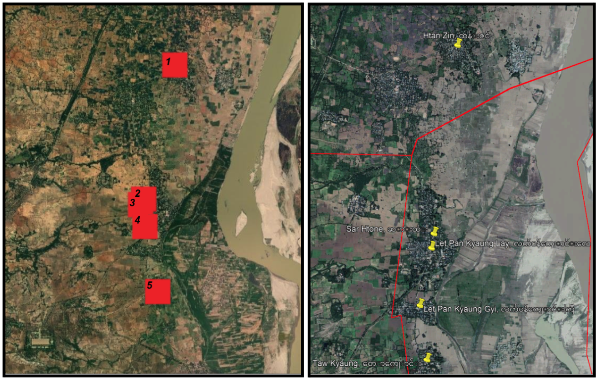
Figure 1: [Left] FIRMS showing fires in the four villages. [Right] Locations of villages identified on google maps.
Sentinel
The locations of fires identified using FIRMS were then further analysed using Sentinel satellite imagery. The areas were visibly damaged, corroborating the FIRMS data. Figure 2 shows the locations of the fires, marked in red. The land is discoloured compared to surrounding areas, indicating burn marks. A false coloured version of the same imagery (Figure 2, right) which uses Thermal IR spectra (Short Wave InfraRed) starkly shows the fire sites.
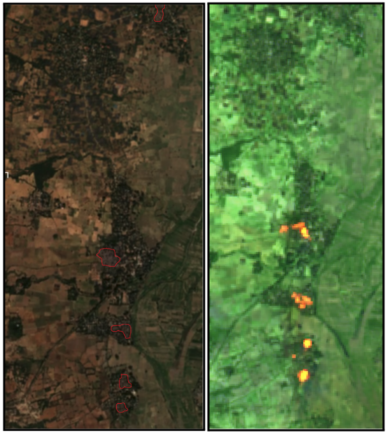
Figure 2: Sentinel satellite imagery. [Left] Visible damage to villages. [Right] False colour version using Thermal IR spectra (Short Wave InfraRed).
Satellite images taken between 26 November and 26 December 2022 of Let Pan Kyun Gyi village and Let Pan Kyun Lay village show the destruction to the towns. By comparing satellite imagery across a month period, it is possible to see the discoloration of the ground, from green and light brown to grey and faint red (see the areas highlighted with the red squares below). On 1 December 2022 (top right) smoke plumes are visible.
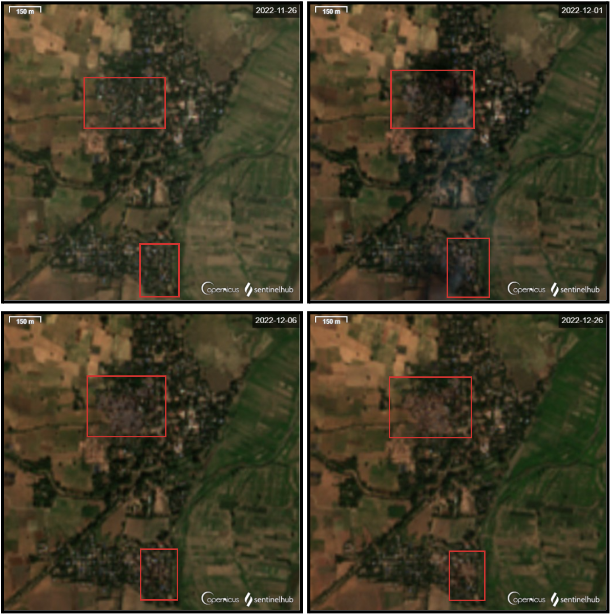
Figure 3: Sentinel satellite imagery of Let Pan Kyun Gyi village and Let Pan Kyun Lay village. [Top Left] 26 November 2022. [Top Right] 1 December 2022, smoke plumes visible. [Bottom Left] 6 December 2022. [Bottom Right] 26 December 2022.
By comparing the satellite images from after the fires with higher resolution imagery, Myanmar Witness was able to estimate the number of houses destroyed or damaged during the fires. This revealed that around 210 houses were burnt across these four villages.
Verification of user-generated content (UGC)
While conducting this investigation, Myanmar Witness identified disparate pieces of UGC and various allegations and claims, largely in reference to conflict in the Sar Htone and Htan Zin village tracts. Through the processes of geolocation and chronolocation, Myanmar Witness has been able to build up a picture of the events which took place across Salingyi township. Fact-based assertions can be made on the location and time that these pieces of content were captured. All imagery has been checked for originality (i.e. if the content has been posted before with a different narrative/time/location).
Timeline of events
30 November 2022 – 1 December 2022
Htan Zin (ထန်းဇင်)
Unverified
0700 (30 November 2022)
Claims on social media state that a group of 150 SAC personnel stopped on the banks of Chindwin river near Htan Zin at around 0700 (source redacted due to privacy concerns). Following this, many houses in the village were burnt. The same source suggests that it was a retaliatory attack after local defence groups attacked a boat carrying SAC personnel travelling down the Chindwin river.
Htan Zin (ထန်းဇင်)
Partly Verified
1920 (30 November 2022)
Clashes were reported in Htan Zin between PDF and SAC. As the claim was not associated with imagery, geolocation and chronolocation could not be undertaken to verify this claim. However, fires in Htan Zin did occur either on 30 November (as per UGC on social media), or in the four days leading up to (as per satellite imagery, see figure 2). The same social media post alleged that two PDF personnel were arrested by the SAC on this day.
Let Pan Kyun Lay (လက်ပံကျွန်းလေး)
Verified
Morning (1 December 2022)
UGC showing a group of individuals who appear to be local defence forces trying to stop the fire from spreading (source redacted due to privacy concerns).
Salingyi Town (ဆားလင်းကြီးမြို့)
Unverified
1400 (1 December 2022)
According to a post on social media, allegedly more than 100 people entered Salingyi town within Salingyi township, after burning the four villages. While the source claims they are a “terrorist group” it is likely that they were referring to SAC personnel.
Geolocations
30 November 2022
Htan Zin (ထန်းဇင်), Salingyi
Verified
Myanmar Witness identified footage of fires, posted on social media alongside claims that the SAC troops disembarked a boat which was travelling down the Chindwin river and set fire to Htan Zin village (source redacted due to privacy concerns). The location was verified using the landscape and place of worship in the visible horizon. The geolocation corroborated the location of the fire as seen in the Sentinel satellite imagery (see figure 2). The report claims the fire occurred on 30 November. Using Sentinel, Myanmar Witness can confirm that the event occurred between 26 November and 1 December.
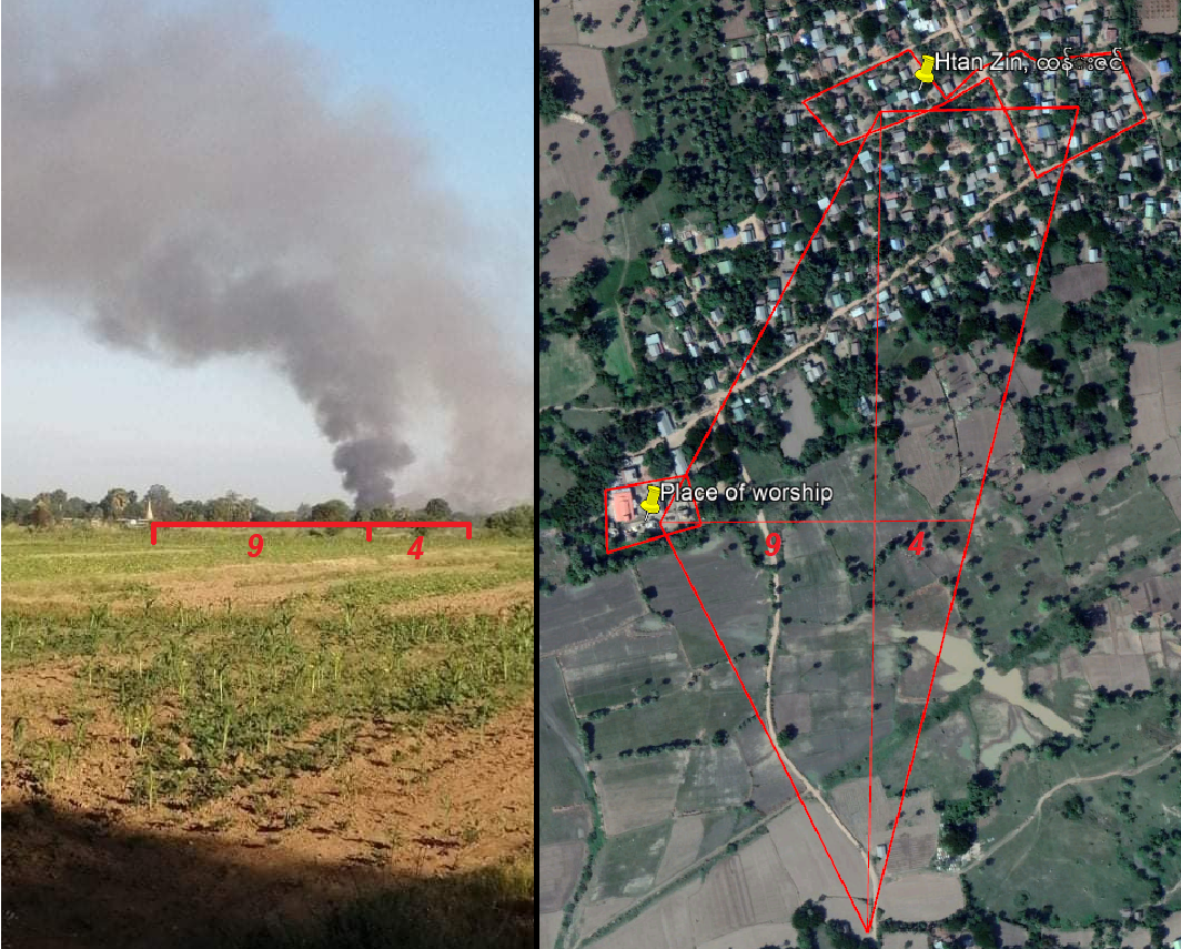
Figure 4: [Left] User-generated content posted on social media and analysed by Myanmar Witness. [Right] Geolocation carried out by Myanmar Witness in order to confirm the location of the fire.
1 December 2022
Let Pan Kyun Lay (လက်ပံကျွန်းလေး), Salingyi
Verified
A video was posted online by Mandalay Free Press showing local armed forces trying to stop the fire from spreading further by putting water on buildings near those which were ablaze. The video claims to be of the fire on 1 December and the locations visible within the video match the location of the fire as identified by the burn marks in Sentinel satellite imagery. Myanmar Witness believes that this footage is original (i.e. it hadn’t been posted online prior to this date).
The key features used for geolocating the video included the orientation of the buildings marked with black boxes, the burning buildings (red boxes) and the stone temple pillars (orange boxes) in the open area.
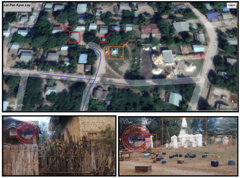
Figure 5: Geolocation of the video by Myanmar Witness which confirms that the fire took place in Let Pan Kyun Lay village.
As is visible within the video, there is a slight shadow towards the west, indicating that the video was likely filmed before noon. However, the smoke, fires and possible cloud coverage do decrease the clarity of the shadow, limiting Myanmar Witness’ ability to precisely chronolocate the footage.

Figure 6: A still frame taken from the video showing a slight westerly shadow which can be used to identify a rough time frame within which the video was filmed.
Social media users also released images which they purport to be from the event, some of which were geolocatable. The images further corroborate claims related to the destruction of the town. Myanmar Witness was able to geolocate the image below, which was uploaded to social media, using the orientation of the roofs, the road, and the flora.
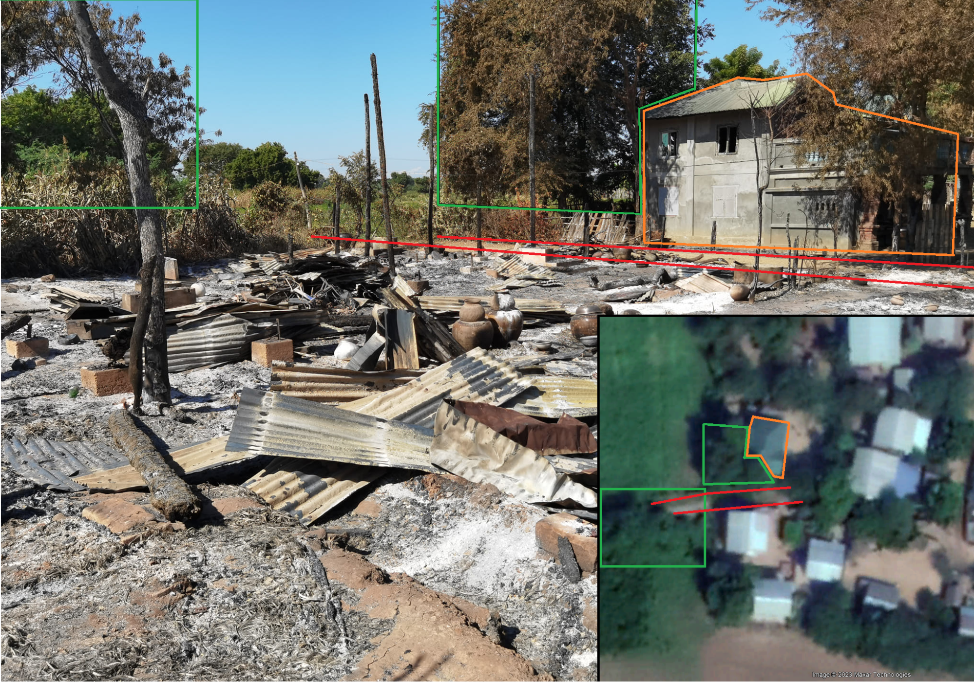
Figure 7: Images [warning graphic] uploaded to social media showing destruction to Let Pan Kyun Lay village and associated geolocation by Myanmar Witness.
Another image uploaded by the same social media user was also geolocated by Myanmar Witness to Let Pan Kyun Lay village. In the following verification, the place of worship was a key identifier, together with another UGC video, that had some of the features in the image seen from different angles (source redacted due to privacy concerns).

Figure 8: Images (graphic) uploaded to social media showing destruction to Let Pan Kyun Lay village and associated geolocation by Myanmar Witness.
Social media posts related to this event also contained graphic imagery. For example, Myanmar Witness identified footage of one burnt corpse, and a half burnt head. These have been checked for originality and Myanmar Witness believes they had not appeared online prior to this event, increasing the likelihood that these victims were associated with this event. The claims associated with the images suggest that they were two elderly people. However, their exact cause of death is unclear.
Future monitoring
The conflict between local defence forces and the SAC continues within Sagaing state. Salingyi township has been the site of many arson attacks, as can be seen on the Myanmar Witness Fire Map. This spot report has verified a set of connected fires along the Sar Htone (ဆားထုံး) and Htan Zin (ထန်းဇင်) village tracts; In December 2022 alone seven other fire events happened in Salingyi township. Myanmar Witness will continue to monitor fires as well as claims of arson attacks and conflict in an attempt to highlight the tactics being employed which directly affect communities in Myanmar.
Abbreviations
Fire Information for Resource Management System FIRMS
Internally Displaced Person IDP
National Aeronautics and Space Administration NASA
People’s Defence Forces PDF
State Administrative Council SAC
User-Generated Content UGC


