Open-source evidence shows that as Russia’s invasion of Ukraine commenced, Russian forces established a temporary camp within the Chernobyl Exclusion Zone, and transported military equipment through the exclusion area to be used in Russia’s invasion of Ukraine.
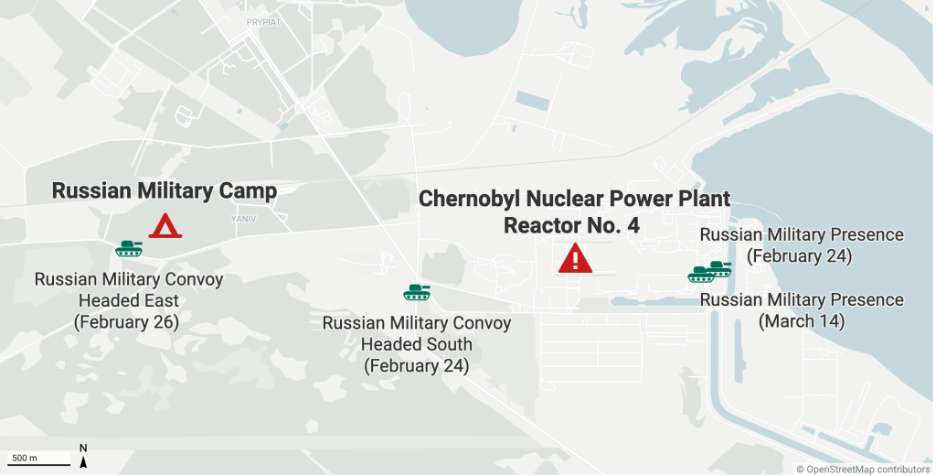
Figure 1: A map showing Russian military convoys and presence around the Chernobyl Nuclear Power Plant between February 24 to March 14.
Between late February and early March, during Russia’s occupation of the area a camp was set up a little over three kilometres from Chernobyl’s Reactor No. 4.
Analysis of satellite imagery, as well as drone footage filmed over the camp shows that there was extensive digging for reinforcements and temporary buildings with roofs were set up at the site.
Geolocation of footage and satellite imagery also shows that on at least two occasions, large Russian military convoys made their way through the exclusion zone, passing by the camp and moving south towards Kyiv. Additional geolocation work identified several images and videos showing Russian forces close to Chernobyl’s reactor sites.
Mapped data with radiation counts indicate an increase in radiation levels in Chernobyl at the time that Russian forces were present around the area.
CIR has also geolocated imagery showing several Russian medical buses in front of a hospital in Belarus.
Specifically, they were seen at the Republican Scientific-Practical Centre for Radiation Medicine and Human Ecology in Gomel. It is claimed that several Russian soldiers suffered from Acute Radiation Syndrome. However, later reports alleged that 26 people were hospitalised and 73 were in critical condition.
Satellite Imagery Analysis of the Russian Camp Near Reactor No. 4
Satellite imagery shows the construction of a Russian camp 3.5km from Chernobyl’s Reactor No.4. The camp was built at some point between February 26, 2022, and March 16, 2022. It was geolocated to: 51.389, 30.048.
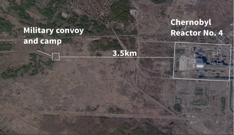
Figure 2: Planet imagery from February 26 showing Chernobyl’s Reactor No.4, The Russian Military Convoy, and Russian Camp.
Imagery provided by Planet shows the camp close to Chernobyl’s reactor. The screenshots below show the detected change in environment and location of the Russian camp.
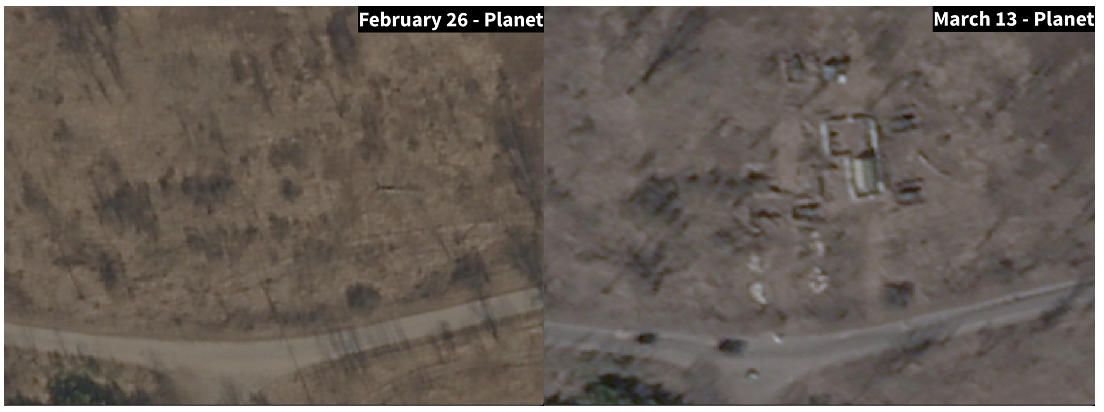
Figure 3: Planet imagery showing formation of the Russian camp between February 26 and March 13.
The imagery from February 26, 2022, also shows a 32-vehicle convoy seen near the camp. It is not known whether this convoy had stopped at the camp, or whether it was passing through the area.
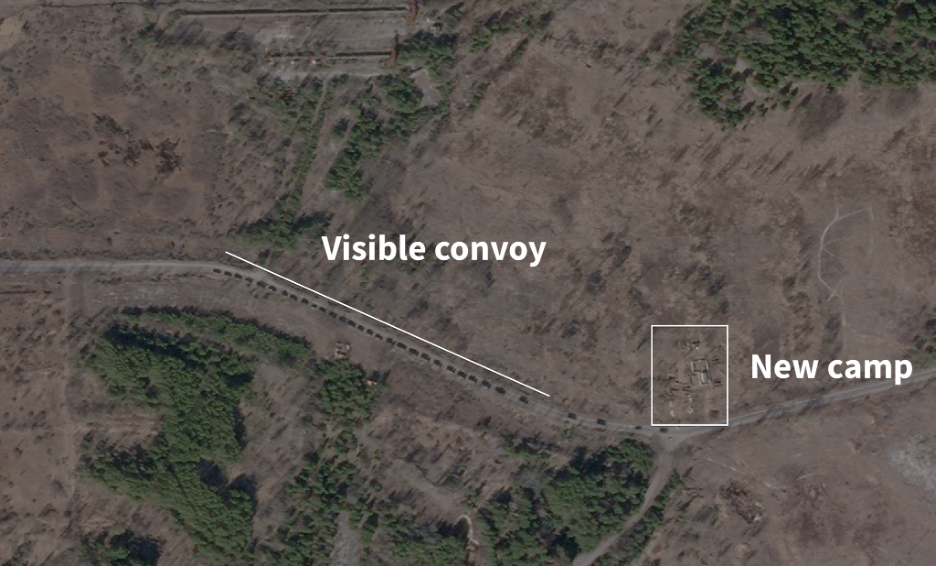
Figure 4: Planet imagery from February 26 showing the convoy and the construction of the Russian camp.
In April 2022, the remnants of this camp were filmed via drone, and uploaded to YouTube. The Eyes on Russia Team have confirmed that the footage originates from the location of the Russian camp, as it matches the features of the site observed on the Planet satellite imagery from April 7, 2022.
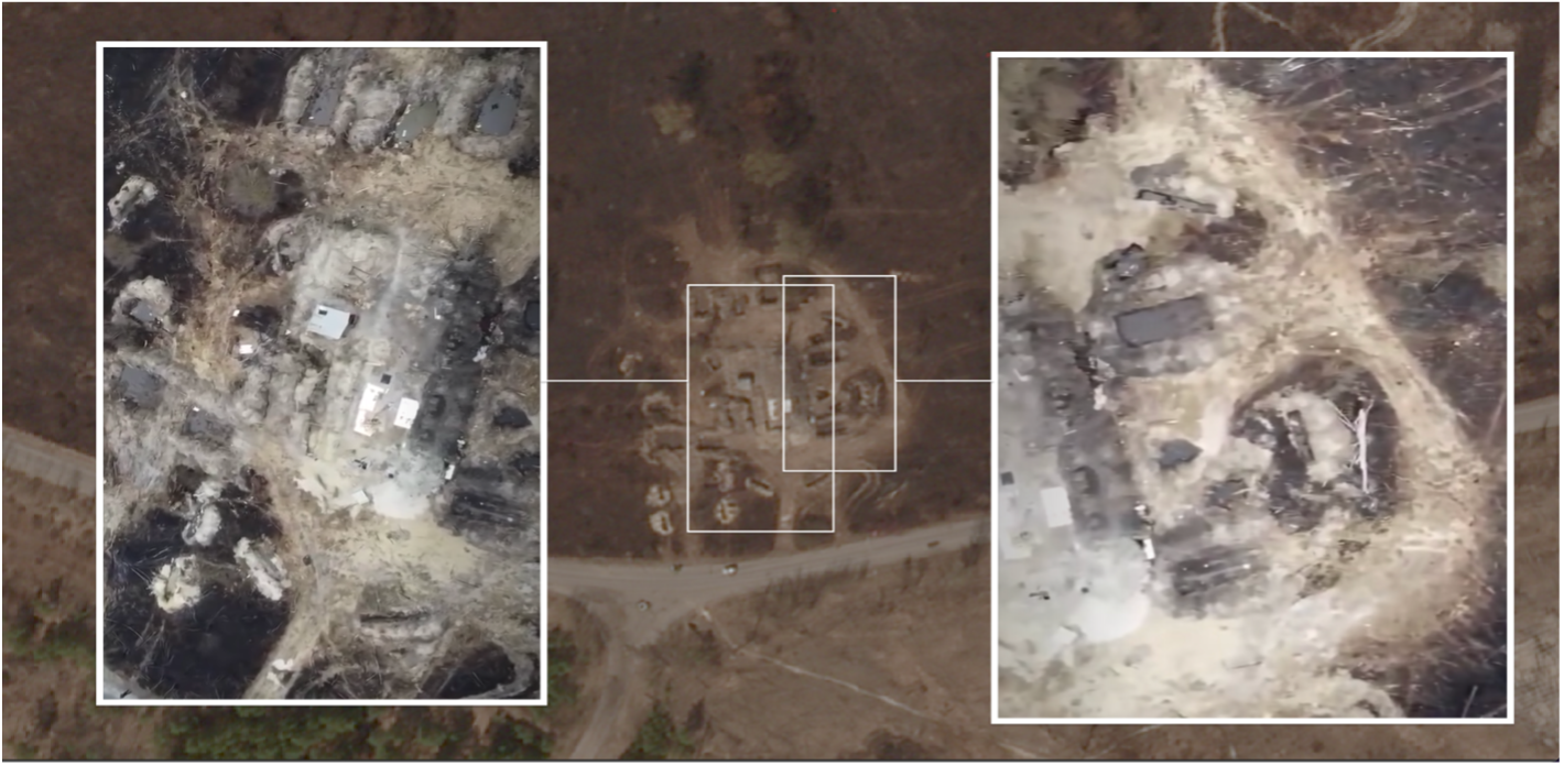
Figure 5: Geolocation of drone footage to Planet satellite imagery dated April 7, 2022.
Further satellite imagery from March 28, 2022, shows that there was a large fire burning within close proximity to the camp, as seen on Sentinel Hub.
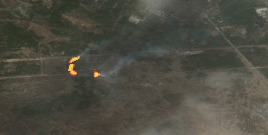
Figure 6: Satellite imagery from Sentinel Hub showing two fires burning on March 28, 2022.
NASA FIRMS data, which identifies heat signatures from space, picked up signals of heat across this location, and across the location of the Russian camp. This data indicates that fires were actively burning through the camp and around it on March 28, 2022.
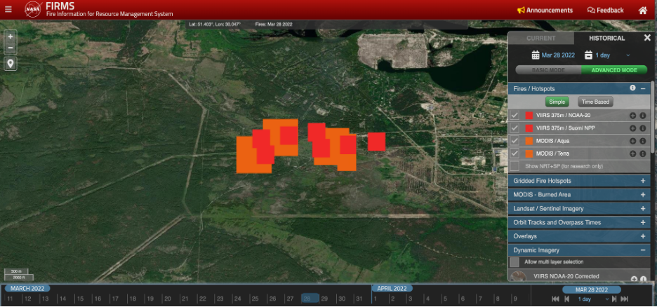
Figure 7: NASA FIRMS data showing heat signatures on March 28.
Given the location of the newly constructed camp, and the risk to levels of radiation, there is a concern that soldiers may have suffered effects from contamination.
On March 30, an image was shared on social media showing several Russian medical buses in front of a hospital in Belarus. Online claims stated that several Russian soldiers suffering from Acute Radiation Syndrome had arrived at a hospital in Belarus from the Chernobyl Exclusion Zone in Ukraine.
The seven medical PAZ buses were geolocated to the Republican Scientific-Practical Centre for Radiation Medicine and Human Ecology in Gomel.
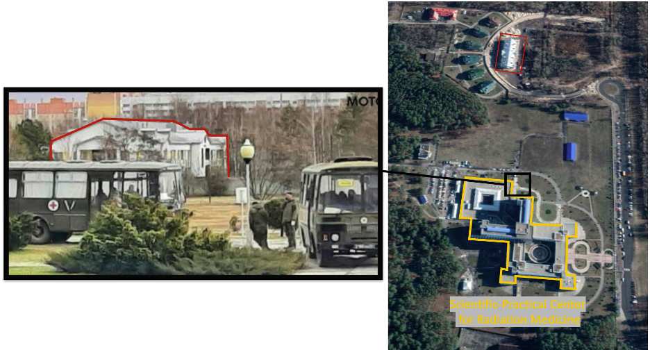
Figure 8: Geolocation of Russian medical buses to the Scientific-Practical Centre for Radiation Medicine.
A report from Nosovsky Anatoly Vladimirovich, the Director of the Institute for Nuclear Power Plant Safety of the National Academy of Sciences of Ukraine, said that the medical facility housed Russian servicemen who were in the Chernobyl Exclusion Zone.
Translated text from the report states that allegedly 26 people were hospitalised and 73 were in critical condition, all of whom were taken to hospitals for “forced recovery”. However, Vladimirovich stated that the Gomel Centre for Radiation Medicine and Human Ecology was likely used to treat ordinary injuries rather than radiation injuries.
Finally, Vladimirovich further claimed that soldiers would have been “unaware of the rules of conduct in radioactively contaminated areas, without personal protective equipment and neglecting the rules of radiation safety, the ‘occupiers’ harmed themselves”. Additionally, the report stated that long-term effects of the contamination might not show for some time.
Verification of Russian Military Movements in The Chernobyl Exclusion Zone
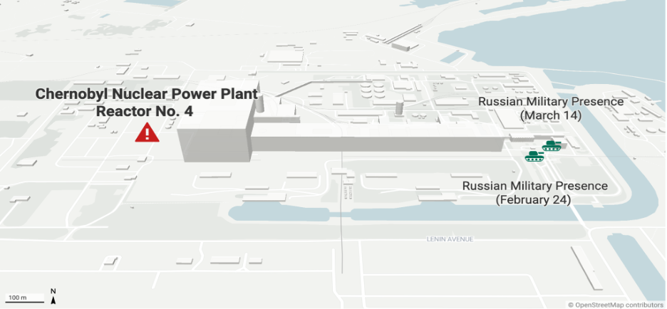
Figure 9: A map showing Russian military presence in Chernobyl’s Nuclear Power Plant between February 24 and March 14.
The convoy seen on the satellite imagery was not the only time the Russian military had moved through the area. Open-source evidence indicates that Russian military assets had passed through Chernobyl numerous times. The route was a direct path from Belarus into priority areas of Russia’s invasion in Northern Ukraine.
In one piece of footage from February 24, 2022, a Russian convoy is seen moving past Chernobyl’s main reactors.
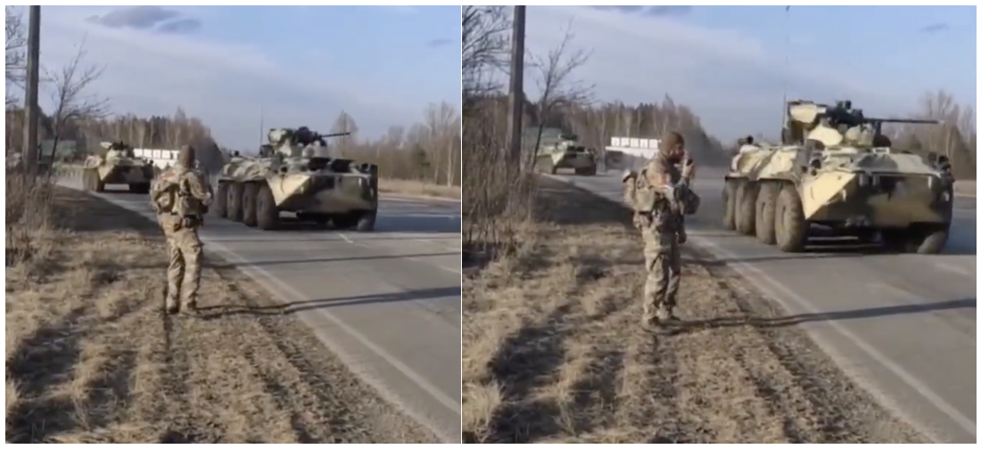
Figure 10: Footage showing the movement of a Russian convoy through Chernobyl on February 24, 2022.
This footage was identified to have been filmed on a road close to the Russian camp, just 1.5km from Chernobyl’s Reactor No.4. The footage was geolocated to: 51.387220, 30.077048.
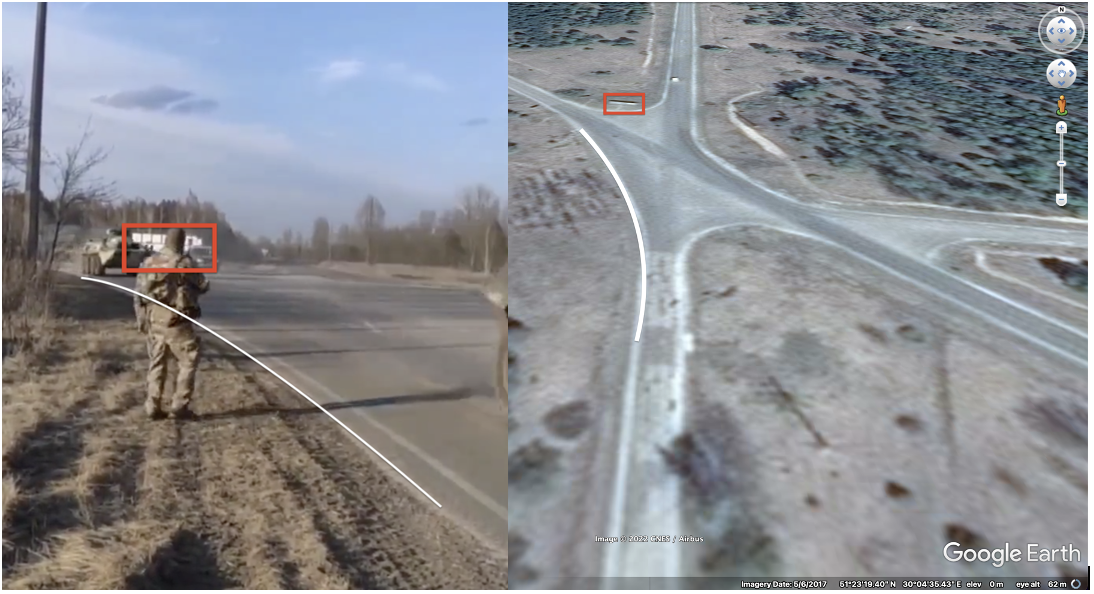
Figure 11: A screenshot showing the Geolocation of a Russian convoy in Chernobyl on February 24, 2022.
Further footage was uploaded on February 24 showing Russian forces in-front of the Chernobyl Nuclear Power Plant near Chernobyl NPP Unit 2. The forces were geolocated to: 51.388379, 30.110766.
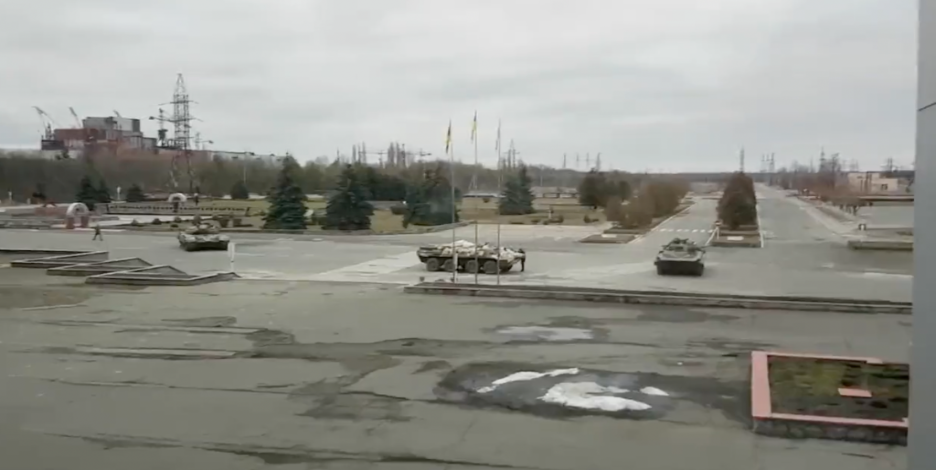
Figure 12: Russian forces in the Chernobyl Nuclear Power Plant on February 24, 2022.
Images published on Telegram on March 14 showed further presence of Russian forces, close to Chernobyl’s Reactor No.4. These forces were geolocated to: 51.388240, 30.110915.
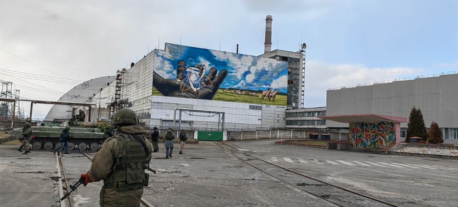
Figure 13: Russian forces seen at Chernobyl’s Nuclear Power Plant in March 14.
While it is not possible to exactly verify how many forces passed through Chernobyl, the head of Ukraine’s State Agency for Exclusion Zone Management, Yevhen Kramarenko said in a briefing in Lviv on April 3:
“According to Chernobyl workers’ estimates, in the five days before the final withdrawal of Russian troops from the exclusion zone, approximately 10,000 units of equipment passed through Chernobyl, including tanks, wheeled vehicles, tankers, and engineering equipment from near Kyiv.”
Kramarenko stated that (Russian troops) “could have been infected then, when they were moving towards Ukraine, and now, when they were going to Belarus”.
Kramarenko also claimed that in the first days of the war, 500-600 units of heavy Russian military equipment moved through Chernobyl every-day. He states that at the station where Russian forces established their main headquarters there were approximately 50 units of military equipment and 1,000 soldiers. While in Chernobyl, a commandant’s office was established containing up to 500 soldiers.
Radiation Levels in Chernobyl’s Exclusion Zone
In April, radiation safety experts visited the site in Chernobyl where ground was dug up and a Russian camp was constructed, as verified by figure 14.
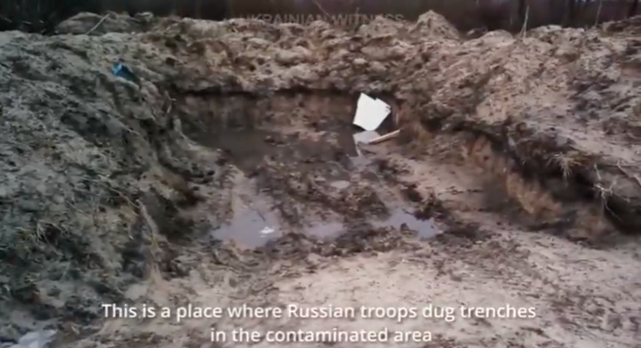
Figure 14: A screenshot from a video showing the Russian camp near Chernobyl’s Power Plant.
The Eyes on Russia team has geolocated the footage being filmed by radiation safety experts at the Russian camp to: 51.3894372,30.0482897.
The radiation safety experts’ team on the ground used a dosimeter to take radiation readings throughout the location where the Russian camp was established. They reported that there were “excess” readings and that the camp was in a contaminated area.
The footage also references the fires that have burned in the area near Chernobyl, indicating that the video was filmed after the fires took place within, and around the Russian camp site on March 28.
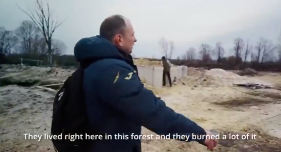
Figure 15: A screenshot from a video showing the Russian camp near the Chernobyl Power Plant.
Radiation readings were also obtained through the use of the Safecast Map, which indicates the level of sieverts, or micro sieverts per hour (μSv/h) – a unit measure used to examine radiation dose quantities in a determined area.
Some of the radiation levels along the road by the location of the camp indicate readings between 0.43 – 1.31μSv/h. Along the roads where Russian convoys were moving in the area, readings were registered between 3.99 – 10μSv/h.
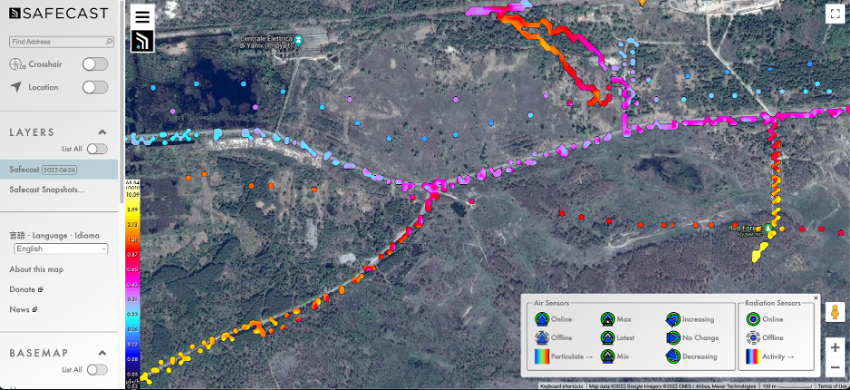
Figure 16: A Screenshot of the Safecast Map showing location of camp.
While these readings present historical data of the underlying radiation levels in the area, data from the SSE “Chernobyl Nuclear Power Plant” indicated high rises in radiation levels in late February.
Reporters from the BBC interviewed a Sheffield University nuclear materials expert, who claimed that “the increased movement of people and vehicles in and around the Chernobyl zone will have kicked up radioactive dust that’s on the ground”.
The readings from the power plant indicated a jump to 65μSv/h, which was significantly higher than normal levels in the Chernobyl exclusion zone.
You can download this report as a PDF.

